This article presents an integrated methodological approach for water allocation and water forecasting in the Panj-Amu River Basin of Afghanistan, a case study of Taloqan Sub-River Basin. Since water allocation is a process for equitable sharing of water and reaching an agreement with the community on these water shares, it is important in reducing conflict over access to water resources. There are three separate estimates needed to make a determination for seasonal water allocation or seasonal water sharing such as water resource estimates, water demand estimates, and water balance estimates. Requirements to manage water-sharing need to be considered such as structured communication with water users and water-related organizations, processes for monitoring water-sharing, policing water shares, and updating water supply and demand forecasts. To manage water resources in a river basin in the longer term, various estimates and processes are needed in river basin planning hindcasting and forecasting water availability, allowing for variability in water availability, water demand estimates in river basin planning, and water allocation in a river basin plan. The two methods (snow cover against flow, and percentiles based on the available recorded flow data) help the River Basin Agencies/Organizations how to allocate water among all water users inside the sub-basin and even at the transboundary level. This could help to increase water efficiency and agricultural productivity as climate change already brought changes in precipitation and discharge. A clear understanding of the availability of water at the resources could help in planning and will reduce the conflicts among all water users.
Keywords: Ministry of Energy and Water, River Basin Agency, Water Allocation, Water Forecast, Water Demand, Water Balance.
Introduction
Freshwater is a finite and vulnerable resource, essential to sustain life, development and the environment. Since water sustains life, effective management of water resources demands a holistic approach, linking social and economic development with protection of natural ecosystems. Effective management links land and water uses across the whole of a catchment area or groundwater aquifer (Principal No. 1, Dublin Conference (1992)). Population and economic growth in developing countries will put significant pressure on the world’s water resources to meet both future food requirements and water demands in the domestic, industrial and, increasingly, environmental sectors. The challenge is particularly great as water resources are seldom managed in an integrated manner, that is, trans-boundary or across water-using sectors (Claudia Ringler, 2001).
When multiple countries share a river, they compete over available water resources. The upstream country has the first option to use water, which may obstruct the overall efficiency of water use (Barrett 1994). Cooperation between upstream and downstream countries—in the form of a water allocation agreement—may increase the efficiency of water use. Whether cooperation is stable, however, depends on the design of the water allocation agreement. The majority of these water allocation agreements does not take into account the hydrologic variability of river flow (Giordano and Wolf 2003). This is a shortcoming because variability is an important characteristic of river flow. This variability will even increase in many river basins when the effects of climate change on temperature and precipitation proceed as projected by climate simulation models (IPCC 2007). These effects are expected to increase the var- iability of the annual and seasonal flow patterns as well as the frequency of extreme events in many river basins (Arnell 1999; Chalecki and Gleick 1999; Voss et al. 2002; Räisänen et al. 2004).
The Panj Amu flows to the north-west into the Amu River (Amodarya) which drains to the Aral Sea. This river basin produces a large proportion of Afghanistan’s agricultural production. It has a large potential for hydropower production for which there are plans to construct some major reservoirs but as yet relies only on the natural water storage in the mountains. Irrigation in this river basin is from canals which divert water mostly from the mid and lower river across the floodplain and terraces. Although the focus of water management work to date has been on irrigation, there are a number of other water management needs in the river basin. These include water allocation and distribution, management of the flood and water related disasters, urban and rural town water management, rural development and management of upper catchment areas and environmentally friendly management of the river channel and its environment.
The Panj Amu River Basin Agency is an established decentralized agency of the Ministry of Energy and Water, with an area of responsibility for planning and managing water resources defined by the river basin. It has established six Sub-basin Agencies which carry out delegated functions on behalf of the basin agency. The River Basin Organization (RBO) design provides for a River Basin Council which is to act as the main decision making and coordinating agency for water resources in the river basin. The Council is to guide the water management actions of the River Basin Agency (in this case, the Panj Amu River Basin Agency). As yet, the Council is not formed and thus the RBO is developing, but not yet fully formed.
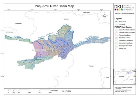
Figure 1. Panj-Amu River Basin Map
Water allocation
Water allocation is the process of sharing water among groups of water users and individual water users within these groups. The water users in the groups may be categorized by the uses to which water is to be applied, such as environmental maintenance, town water supply, irrigation of annual crops, irrigation of permanent crops such as orchards, hydropower and water use in industry and mining. The priority of water use by such groups is set out in the Water Act.
Water stress can limit land capability, re- duce agricultural production, and subsequently amplify the volatility of agricultural commodity prices, adding to challenges in realizing sustain- able rural community. Water stress can also in- duce environmental externalities, and these externalities, in turn, affect economic sectors and the natural environment significantly (Hoekstra 2014; IPCC 2014). Discourses on water scarcity are key to shape people’s understanding of its causes, consequences, and interaction among stakeholders (Hussein, H., Alatout, Feitelson, E 2002).
There are two aspects to water allocation:
- River basin planning in which water availability is balanced against water demands over a long time period; and
- Annual or seasonal water allocation where water demands are managed to balance against forecast water availability for a 12 month period or shorter.
In both cases, the water balance between supply and demand must be made for the entire hydrologic unit (usually a river basin) and must be made at an appropriate time scale (usually not more than a month) to allow for the variability in water supply. Water demands need to be separated into different categories which consider their sensitivity and ability to be managed when restrictions in supply are imposed. Water supply estimates need to consider the ability of infrastructure to ‘time-shift’ water through the use of storage.
Once the balance of supply and demand through the water season is determined, the management task is to allocate equitable amounts to water user groups and then to individual water users within these groups. There are several important tasks in this management process:
— Informing water users of the water supply and demand forecasts and the need for management control
— Monitoring the water sharing arrangements, updating the forecasts, re-calculating the water sharing arrangements and re-announcing the water shares
— Policing the announced water shares
Clearly the underlying task in this management is involvement of the water using community and communicating and gaining agreement to the whole water allocation process.
It is good to have high-quality discharge data available for our rivers, and meteorological data, but in case of non-availability or data gaps the studies confirm that satellite rainfall data can be used as a source of meteorological data which are important for river basin planning and management studies (Blöschl et al. 2013). Even in the recent periods using of the collected data as remote and satellite precipitation products are increased (Näschen et al. 2018, Oduor et al. 2020; Pellarin et al. 2020). Consequently, the production and application of different data which the source are as satellites products (SPPs) has more recently seen an upward trend across many regions around the globe (Harris et al. 2014).
Water forecast method 1: snow cover against flow
The first method correlated mountain snow cover against river flow.
Snow data for the Panj Amu river basin was obtained from the ICIMOD for each 8-day period from 2000 to 2017. The data for Taloqan sub basin was clipped from the main Panj Amu river basin using ArcGIS. The number of pixels (500x500m) for the snow and non-snow areas for each 8 days was counted separately and exported to an Excel sheet, converted to km 2 and the average snow-covered area for each month determined.
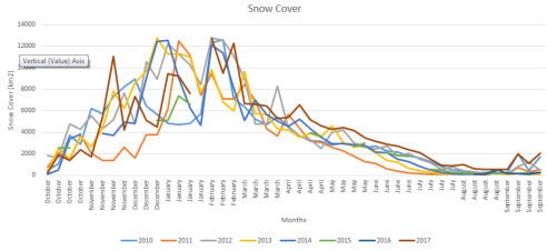
Figure 2. Average of snow coverage area during the moths from 2010 to 2017
Monthly flow data for the years 2010 to 2018 for the Taloqan river at Chogha initially received from the Ministry of Energy and Water (MEW), which is taken from the Annual Year Books.
Correlation between snow cover and river flow based on examined the two data sets of snow cover and river flow, it was noted that the annual peaks of snow and flow are in February and June, respectively. Therefore, to get a good correlation, the data sets were aligned so that the peak of snow cover in February aligned with the annual flow peak in June; and the month of March aligned with July, etc. Table 1 presents the two monthly data sets before alignment. Table 2 is the data after alignment by adjusting the snow cover data forward by 4 months.
Table 1
Flow data of Chogha gauge station and snow covered area in Taloqan sub basin

Table 2
Flow data at Chogha and snow data for Taloqan Basin aligned by shifting four months
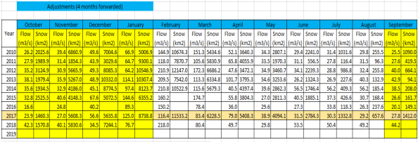
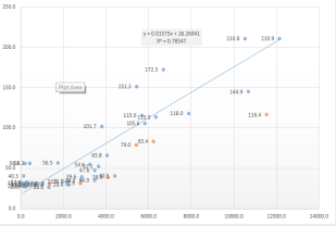
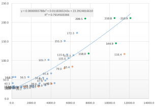
Correlation analysis was done for the snow data and monthly river flow for the months October to September. The correlation result (using the both linear and polynomial trendlines) is plotted in Figure 3. The small improvement in correlation given by polynomial is not considered to be justified given the uncertainty in the data.
|
|
|
|
Linear is used for the trendline |
Polynomial is used for the trendline |
Figure 3. Linear and polynomial trendlines
The linear correlation between 4 month shifted snow cover and average monthly flow can be used to predict the flow. The snow data (X values) and flow data (Y values) allows a prediction of flow to be made 4 months in advance. A satellite image of snow cover, available in near real-time, in February can be analyzed and used to forecast the flow expected in June, using the equation given in Table 3. Based on the correlation coefficient (r2 = 0.78), the accuracy of such a forecast could be quite reasonable.
Table 3
Forecast flow (Y) using linear correlation with snow cover (X)

Water forecasting method 2: percentiles
To overcome the snow data limitations, a second method was developed for a short-term (3-month) forecast. This method uses only the recorded/observed flow data. The forecast is based on the variability of monthly flow over the period of record. The differences in the monthly percentile flows for the current and future months, from 10 to 90 percent exceedance, when added to the recorded flow for the current month, gives the probability of flow for future months, thus predicting the future river flows. This simple method is especially useful as it can be effectively used in the critical month of April to estimate the expected peak of annual flow in June. The simplicity of the method also allows monthly updates to give greater confidence in the forecast.
The percentile exceedance of the flow data for Chogha gauge station from 2010 to 2018 were calculated and are shown in a Table 4. These percentiles are the flows which will be exceeded in x % of years. The analysis is based on a water year, which starts in October and ends in September of the following year. The recorded flow for 2015 and 2017, shown in red, was found from an examination of the daily recorded flows to contain errors. For this reason, the data for these two years was not included in estimating the percentiles.
Table 4
Calculation and percentiles sheet of the observed data

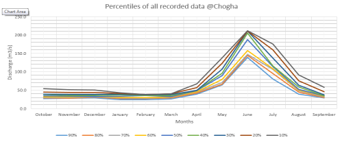
Figure 4. Percentiles of all recorded data for Taloqan River at Chogha
It can be seen from Figure 4 that the percentile exceedance flow curves converge at the annual peak flow month of June. We understand that this result is a figment of the recorded data which underestimates high flows. The river gauging station at Chogha has a sand and gravel bed which mobilizes during high flows, increasing the cross-section of the river and hence its carrying capacity with little change in the water level. Although this gauging station cross-section is equipped with a cable way, there is great difficulty in measuring the cross-section’s depths during high flow because of the very high velocities. It may be possible to increase the accuracy of cross-section measurement during high flows by using a heavier weight on sounding line, or perhaps some other measurement system could be used, such as an echo-sounder.
We believe that in reality the annual peak flows for 30 %, 20 % and 10 % are under-estimated.
The percentile data is used with the observed river flow for the current month to give a forecast, as described earlier, by adding the differences in the monthly percentile flows for the current and future month. This forecast, made in April 2019, is for Taloqan river flow at Chogha and is shown in Figure 5. The reason that the 30 % and 10 % forecast flows for June 2019 seem in the wrong order is related to the inaccuracy of high flow measurement discussed above.
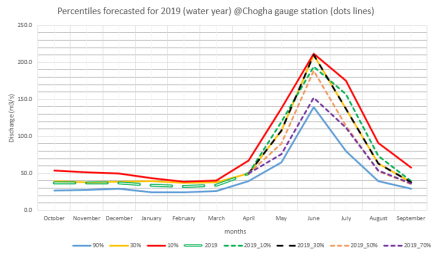
Figure 5. April 2019 forecast Taloqan River flow at Chogha
In Figure 6, the forecast flow is shown for the calendar year along with the monthly 90 % (low) and 10 % (high) and recorded June flows (the bars are for 2016, 2017 and 2018). The forecast has been extended to December 2019.
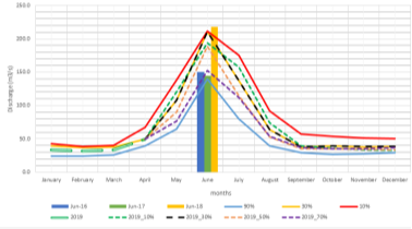
Figure 6. Forecast Taloqan River flow at Chogha for the calendar year
Linking Water Forecast to Water Sharing
A conceptual process for water forecasting and allocation shown below in Figure 7. Given the data and implementation capacity expected in MEW and the SBA, there has been provided capacity building to staff of the Taloqan SBA to implement a simpler process of water forecasting and allocation which uses currently available data information and methods and in use within MEW, such as the Annual Water Forecast based on snowmelt.
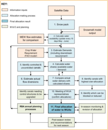
Figure 7. Proposed water allocation process in Taloqan SBA
Links Between Water Allocation and Other Water Plans
Water allocation can be applied at national, regional, basin and sub-basin levels. These allocation plans need to be linked to plans for water using developments such as irrigation and town water supply, and to plans for flood control, hydropower and water resource protection. Water allocation planning involves consideration of the total water resources available within a basin. This can include surface and groundwater supplies, as well as water from inter-basin transfers. The amount of water available for allocation will be a function of this total volume, less:
— water that cannot, in practice, be used (for example, water that cannot be stored or used and passes during uncontrolled flooding)
— water which needs to be retained in the river system to meet ecological needs (i.e., environmental flows).
Water allocation is best determined in the context of a long-term plan, with a minimum term of five years but there may be up to 15 years between review and revision. Such a plan provides the needed stability for investment decisions by the basin community, in agriculture, industry and mining, and town and city development. It also provides the basis for water-related natural resource management in forestry, watershed management, and river ecosystem management.
But should a long-term water allocation plan not yet be developed; seasonal water allocations should be made and should not be deferred while the plan is being developed.
In the case of the Panj Amu River basin, long-term planning is yet to be completed and an urgent need exists to manage water shares between water users in the basin. This need arises from requirements for equity between water using sectors and equity among irrigators upstream and downstream, and at head and tail of canal systems. For this reason, as this paper is prepared specifically for the Panj Amu River basin, the discussion of water allocation for seasonal water sharing has been placed before that concerning water allocation in river basin planning.
Water Allocation for Seasonal Water Sharing
Water allocation for seasonal water sharing is best undertaken within the context of a river basin plan that sets out the water shares for different uses and groups of users. However, this ideal situation is often not met and water sharing must be managed among existing water users without guiding principles and expectations for water shares being known among water users. In such a case, relative reliabilities of supply between different groups of water users will not be public knowledge within the basin community and more widely in the community. Therefore, advice about the other water users in the basin, their need for water and the required reliability of supply, about the environmental needs within the river and the importance of maintaining river biodiversity, should be part of the information provided at a seasonal water sharing meeting.
In addition, seasonal water sharing must respond to timescales which are set by the yearly seasonal calendar and, because of the very high proportion of water use demanded by agriculture, the relationship of agricultural water requirements to agricultural planning, decision making and crop production.
In the Panj Amu River basin, the pattern of river flow and that of agricultural water demand are closely synchronized. The flow in the river is just starting to increase at the same time as farmers are making decisions on crop planting. Thus there is a limited amount of time to communicate with water user groups, and to establish understanding of the expected water availability, the uncertainty associated with the forecast water availability and the possible responses to water shortage by the various water user groups. Well prepared presentations and handouts can assist in overcoming these issues.
The water available for sharing among water users should be that remaining from the forecast river flow after meeting environmental requirements. The pattern of water demand through the year and the diversion capability of offtakes will also need to be taken into consideration.
The water estimated to be available is separated into two amounts which will be provided to two broad groups of water users — (i) permanent crop/orchard, industry and domestic/urban water users and (ii) annual crop agricultural water users. High reliability supply is provided for the town, industry and orchard crop water users. The available water first meets the need for high reliability supply and the remaining forecast supply is then divided proportionally among the annual crop water users.
Water Demand Estimates
The major water demand in a river basin is for irrigation. To estimate the irrigation water demand it is necessary to decide on the area which is proposed to be irrigated in the year. This area may be less than the total nominal command area. Further, the initial water demand arising from the proposed irrigated area may need to be reduced in the light of the available water forecast. The reduced area and water demand can be assumed to be proportional, that is, assuming with reduced water supply there will be no increase in water use efficiency. A reduced crop area should be decided in close discussion with the irrigation farming community.
The water demand can be estimated from the irrigated area using a crop water demand per unit of area. The crop water demand can get from a model such as CROPWAT. The total irrigation water demand is obtaining by adding the transmission loss of water diverted from the river to the estimate water to be delivered to the command area. These irrigation demand estimates should be divided into annual and permanent crop estimates.
Water demand for town can be obtained from the town water supply department, normally this is calculated from the population and a water service level of a number of liters per capita per day. The water demand for industry should also be obtained from the provincial governments.
The high security water demand is the sum of the permanent crop estimate (including transmission loss), town water and industrial water demand estimates.
Water Balance Estimates
Water shares for each group of water users (which could be divided geographically into river reaches as well as into the different classes of water use) are determined by allocating water from the estimated available supply in order of priority.
Water balance should be determined in March — April which is the time when farmers are making decisions on planting annual crops. The area of land that farmers prepare and plant should be informed by the annual water forecast. Farmers may gamble on preparing and planting more area than is forecast to be supplied with water, taking a risk that rain will fall and either the crop water demand will be partially met from rain or that additional water will become available.
Information on water available should be updated and fresh advice given to farmers each month after the initial forecast until the peak annual flow for the year is recorded.
Conclusion:
Mainly the river basin agencies and sub-river basin agencies are responsible for both water allocation and water forecasting. They need to have analyzation of the water availability at the resources based on the precipitation and recorded flow data at the river basin. To maximize water efficiency and increase agricultural productivity, it is a need to take these kinds of actions and combat climate change impacts on the water resources. The flow data and precipitations show variability at the basin which has a direct impact on different sectors and all water users. The river basin agencies need to make decisions and update their planning based on the predicted water situation which the water allocation has a direct link with the available water at the source to be equally shared between all users and sectors considering for environmental protections. There are challenges on data collections and water allocation, but need to be taken decisions on all water activities like the recent variability on water resources requires suitable action and planning. The methods which are explained and discussed could be used in all river basin and its result depends on the quality of the data which are using as input data. The water forecasting helps the farmers to know about the water situation and they could take decision what to cultivate, for example, if the water year situation is wet, they could cultivate rice, but if it is normal or dry, they need to think about their crop types and cultivate the crops which require less water. The experience shows that the conflicts on the water will be existing and even increased if there is no great water allocation and forecasting from the responsible organization which we have (MEW, RBA, and SBA) in Afghanistan. Of course, the RBA and SBA need to know about all water requirements and mainly data and information on the main water consumer which is irrigation lands in their river basins, these kinds of activities would help to increase the agricultural products, reduce the conflicts on water, and improve equitable water sharing inside the country and be shared enough water for riparian countries as the Panj-Amu river basin is transboundary river basin, as competition over water resources between the various water uses and users has increased rapidly, especially during the dry season.
References:
- TA9095 Technical Report on Water Forecasting, Landell Mills.
- IPCC (2007) Climate change 2007: the physical science basis, contribution of working group I to the fourth assessment report of the intergovernmental panel on climate change. Cambridge University Press, Cambridge
- Hoekstra, A.Y. 2014. Water Scarcity Challenges to Business. Nature Climate Change 4 (5): 318–20.
- Barrett S (1994) Conflict and cooperation in managing international water resources. World Bank Policy Research Working Paper 1303
- Arnell NW (1999) The effect of climate change on hydrological regimes in Europe: a continental perspective. Glob Environ Change 9(1):5–23
- Blöschl, G., Sivapalan, M., Wagener, T., Viglione, A., & Savanije, H. (Eds.). (2013). Runoff prediction in ungauged basins; Synthesis across processes, places and scales. Cambridge. Cambridge University Press.
- Näschen, K., Diekkrüger, B., Leemhuis, C., Steinbach, S., Seregina, L.S., Thonfeld, F., Van der Linden, R. (2018). Hydrological Modeling in Data-Scarce Catchments: The Kilombero Floodplain in Tanzania. Water 2018, 10, 599.
- Oduor, N.O., Ngetich, F.K., Kboi, M.N., Muriuki, A., Adamtey, N., and Mugendi, D.N. (2020). Suitability of different data sources in rainfall pattern characterization in the tropical central highlands of Kenya.
- Brocca, L., Massari, C., Pellarin, T. et al. (2020). River flow prediction in data scarce regions: soil moisture integrated satellite rainfall products outperform rain gauge observations in West Africa. Sci Rep 10, 12517 (2020). https://doi.org/10.1038/s41598- 020–69343-x
- Harris, I., Jones, P.D., Osborn, T.J. & Lister, D.H. (2014). Updated high-resolution grids of monthly climatic observations — the CRU TS3.10 Dataset. International Journal of Climatology, 34, 623–642. doi.org/10.1002/joc.3711
- Hussein, H. Lifting the veil: Unpacking the discourse of water scarcity in Jordan. Environ. Sci. Policy 2018, 89, 385–392
- Alatout, S. Bringing abundance into environmental politics: Constructing a Zionist network of water abundance, immigration, and colonization. Soc. Stud. Sci. 2009, 39, 363–394.
- Feitelson, E. Implications of shifts in the Israeli water discourse for Israeli-Palestinian water negotiations. Political Geogr. 2002, 21, 293–318.
- Dublin Conference (1992): Dublin Statement on Water and Sustainable Development. International Conference on Water and the Environment, Dublin.
- Claudia Ringler: Optimal Water Allocation in the Mekong River Basin, ZEF — Discussion Papers On Development Policy No. 38, Center for Development Research, Bonn, May 2001, pp. 50.
- Zhang, W.; Wang, Y.; Peng, H.; Li, Y.T.; Tang, J.S.; Wu, K. B. A coupled water quantity-quality model for water allocation analysis. Water Resour. Manag. 2010, 24, 485–511.
- Rehana, S.; Mujumdar, P. P. An imprecise fuzzy risk approach for water quality management of a river system. J. Environ. Manag. 2009, 90, 3653–3664.
