Water is essential for human survival, sustainable development, socio-economic growth, and ecosystem protection. Therefore, as consequence; it's not surprising that the Afghan government, as well as non-governmental organizations, have invested heavily in water projects. Despite these efforts, water has yet to reach some region of the country. In this paper, the most common challenges of the basin reported and water accounting system were outlined and analyzed. This study examines water accounting from a theoretical perspective and suggests methodologies for using water accounting to address the challenges of water scarcity in Harirud River Basin. Furthermore, this research encourages regional water authorities to use water accounting as a framework for evidence-based decision-making and policy development in the Harirud River Basin in order to alleviate water scarcity and ensure sufficient water supply. The objective of the project is formulation water accounting in the Harirud River Basin. The prime expected of water accounting is to account for water use, depletion and productivity. First, it will introduce the key concepts of water accounting, water productivity and efficiency etc. Second, it will make participants aware of the data requirements for WA and introduce some innovative ways of data collection. Finally, the training will provide examples of the process of assimilation and interpretation of the data and the results of some water balance studies.
Keywords : GIS, Irrigation water management, spatially distributed database, Remote sensing.
- Introduction
In Afghanistan, ensuring water security is crucial for future agricultural output and other livelihood needs. Agriculture contributes roughly a third of national economy and over two third of employment, especially in rural areas. Afghanistan’s economy is essentially water dependent. There is an urgent need for gathered water resources-related data sets that can be commonly understood by hydrologists, economists, agronomists, legal experts, social scientists, and political scientists. A common system of water accounting has so far been missing as an important element in the emerging debate of global water governance, and Afghanistan is no exception. Water accounting is a technique for reporting water resources that includes hydrological processes, water distribution to competing sectors, water consumption, and ecosystem services resulting from water use. Further to data sheets, tables and maps, decision makers need to understand the band width of uncertainty inherent to both the input data and the results of water accounting. In this regard, I am interested in water accounting principles including remote sensing and geographic information system (GIS) methods. The overall objective of this research is to achieve improved data and information on water resources in Harirud River Basin while the purpose is to build further information in water accounting and auditing methods. The purpose is to introduce readers to the fundamental concepts of WA and lay the foundation for the introduction of more advanced concepts and terminologies in WA, such as GIS and remote sensing methods.
Study area
Harirud Murghab Basin is located between 34° 39′ and 35° 55′ N Latitudes and 66° 43′, and 61° 12′ E Longitudes [1,3]. Harirud River Basin is located in the western part of Afghanistan (Figure 1), which is relatively more developed than other basins in that area of the country [2]. The Analysis focuses only on the Lower Harirud River Basin, all of which lies in Herat Province. The study covered the following eight districts in the Province specially Salma Dam:
- Kohsan
- Ghorian
- Zendajan
- Injil
- Guzara
- Pashton Zargon
- Obeh
- Chesht-e-Sharif
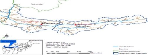
Fig. 1. Lower & Upper Harirud River Basin Boundaries [4]
- Methodology
The research relied on primary and secondary data obtained from field surveys, documents review and Key Informant Interviews. The study started with a review of the appropriate literature in order to get a good understanding of the study background, assess what kinds of data was available, and determine what outstanding I would need to collect data. Then, the data collected through a combination of field surveys, interviews and review of secondary data from government documents and other studies. Key informant interview respondents were selectively for their expertise or perspective on the research’s intended activities.
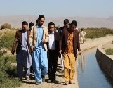
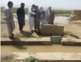


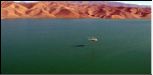
Fig.2. Research related pictures from interviews and site visit
The methodology for this study is based on the following:
Site visit in Herat districts to have real sense of current irrigation situation.
Meetings with individuals and organizations for discussion and collection of information
Collection of information, reports, data, drawings and photographs from these in country individuals and organizations as well as other sources.
Using of the remote sensing and ArcMap10.3 applications for the analysis.
Key datasets from WaPOR database used for WA+
Preliminary assessment of WaPOR data using other global datasets and available observations
The rapid assessment procedure for WA+ Resource Base Sheet
The assessment procedure for WA and the methodology used to assess the impacts of irrigation on the Harirud
Conservation of Mass for WA:

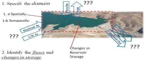
Fig. 3. Salma dam sketch
The domain was typically identified based on the questions I asked and the data I have collected.The interested time period or temporally domain is 2014 (Figure3).
-
Discussions
- Importance and impact of Salma Dam:
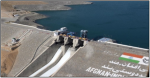
Salma dam also known as the Afghan-India Friendship Dam (Figure 4) in Chesht-e- Sharif district, Herat province was built to meet the irrigation water requirement of 75000 Ha of cultivable land. Table 1 shows the dam’s physical characteristics [8].
Table 1
Salma Dam Physical Characteristics
|
Item |
Description |
Item |
Description |
|
General |
Height |
107.5 m | |
|
Latitude |
N 34˚ 24’ |
Length at top |
551 m |
|
Longitude |
E 63˚ 49’ |
River bed level |
1,547 m |
|
Catchment area |
11,700 km2 |
Top of dam |
1,647.5 m |
|
Maximum annual precipitation |
300 mm |
Type |
Horse shoe |
|
Minimum annual precipitation |
100 mm |
Diameter |
8.5 m |
|
Maximum recorded annual flood |
723 m3/s |
Length |
630 m |
|
Minimum recorded annual flood |
99 m3/s |
Invert |
Level at inlet portal 1,552.42 m |
|
Design flood |
2,100 m3/s |
Spillway | |
|
Diversion tunnel capacity |
1,115 m3/s |
Crest level |
1,633.5 m |
|
Reservoir |
Bottom level |
1,600 m | |
|
Maximum water level |
1,645.84 m |
Length |
154.95 m |
|
Full reservoir level |
1,643.5 m |
Flip bucket |
1,579.69 m (invert) |
|
Maximum draw down level |
1,602 m |
Spans |
3 Nos. each 8 m wide |
|
Gross capacity |
633 MCM |
Piers |
2 Nos. 7m and 5m thick |
|
Live storage capacity |
514 MCM |
Passes |
5m |
|
Dam |
Discharge |
15 m3/s for reservoir drawdown 1,602 m | |
|
Type |
Earth and rock fill |
Sill level of the sluice |
1,587 m |
As part of this analysis, I looked at the Salma dam’s past operation. The observed dam release for the year 2018 shows that the Salma dam’s water release was mainly for power generation, with irrigation and other utilization such as environmental. The total monthly water outflow and elevation variation of the reservoir is presented in Table 2. Salma dam’s past operation data was based on MEW recordings from the field stations. Furthermore, Figure 5b summarizes the Salma dam's water outflow statistics. During the 2018 operating year, the highest turbine outflow was 350 Mm 3 , while the lowest turbine outflow was 25 Mm 3 . The months with the largest outflows are April and October, while the months with the lowest outflows are December till February. Figure 5a shows a summary of reservoir elevation statistics at the Salma dam. During the 2018 year of operation, the highest reservoir elevation was 1,643.1 m in May, and the lowest reservoir elevation was 1,599.7 m in December. According to involved persons, the Salma dam operation release was primarily for power generation. The demands of irrigation and environmental flow were not adequately considered in the release planning. The average rainfall in the basin has decreased in recent years, leading to a situation that calls for better water management. Over the months of December through April, irrigation and environment demand is met through rainfall. Thereafter, water release should be managed based on all the actual demands.

Fig. 5. a) Salma Dam Operation in 2018 (Recorded Elevation), b) Salma Dam Operation in 2018 (Water Outflow) [6]
3.2. Precipitation
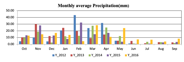
For several applications and disciplines connected to water management such as water accounting, precipitation is one of the main variables. The monthly-average precipitation for deferent years shows that hydrological years typically start in October at the end of the dry season. The annual precipitation over the Harirud River Basin varied between 235 to 288 mm/year during the period of 2012–2016. Figure 6 shows the average monthly precipitation (mm) recorded at automatic weather station — Band-e-Salma in the Harirud River Basin for the hydrological years 2012–2016.
3.3 Land use Class
The WaPOR datasets for precipitation, actual evapotranspiration and interception, and land cover class were used to describe precipitation excess (water generation), and thus, lateral transport of water from water surplus to net water consumption per land cover class. Land cover classes that satisfy P > ETa are considered water generating areas while those fulfil ETa > P are net consumers of water [10]. The WaPOR database provides a yearly land cover maps (LCC) for the Afghanistan River Basins, which is based on the Copernicus land cover product. The land cover map provides 14 land use classes (Figure 7). It declares that most of the area is covered by forests and agricultural areas, and limited sections in the lower part are dedicated to build-up areas. As shown by this map, most of the rangeland is located in the upper Harirud, while most of the agricultural and barren land is located in the lower part of the basin. The main urban hub in the area is the city of Herat. The table 2 presents land use description and input parameters, since the table 3, 4 indicates results of the water sheets. Excess rainfall that is not consumed via evapotranspiration can generate surface runoff, interflow, drainage, groundwater recharge, seepage, and base flow [10]. To see if this low excess rainfall greatly reduces the outflow estimation in these supposedly «dry» years, a water balance assessment with water storage change is needed. Excess rainfall that is not consumed via evapotranspiration can generate surface runoff, interflow, drainage, groundwater recharge, seepage, and base flow [10]. The annual average rainfall in the accounting period was 278.86 mm in the water years of 2013–14. The year 2013–2014 with an average precipitation of 278.86 mm was considered as a dry year when compared to long term basin average of 378 mm [7]. To see if this low excess rainfall greatly reduces the outflow estimation in these supposedly «dry» years, a water balance assessment with water storage change is needed. The same calculation was done for each land cover class to identify net water generating and consuming land use class (Table 2, 3). It can be seen here that about 46099 km2 of the Harirud River Basin area is made up of the Rangeland class, which is the biggest net water consumer (5,854.62 Mm3/year). This class receives 14,290.80 Mm3/year of total precipitation, while contributing 8,436.18 Mm3/year of total ET (Table 3). Rain fed Agricultural Land and Barren Land are the second and third largest net water consumers, and consume 1,297.02 and 543.24 Mm3/year (Table 3). Table 3 also shows that the relative contribution of all the land cover classes to total ET resembles the distribution of Precipitation, which means ET of each class is greatly limited by Precipitation. Contributions of the land cover classes to annual precipitation (P) and actual evapotranspiration (ET) of the Harirud River Basin for the hydrological year
|
LU-Raster Value |
DescMod |
|
1 |
Barren Land |
|
2 |
Built-up |
|
3 |
Forest and Shrubs |
|
4 |
Fruit Trees |
|
5 |
Fruit Trees/Irrigated Agricultural Land |
|
6 |
Irrigated Agricultural Land |
|
7 |
Permanent Snow |
|
8 |
Rain fed Agricultural Land |
|
9 |
Rangeland |
|
10 |
Rangeland/Barren Land |
|
11 |
Rangeland/Rain fed Agricultural Land |
|
12 |
Sand Cover |
|
13 |
Vineyards |
|
14 |
Water Body and Marshland |
2014 has been shown in Figure 8.
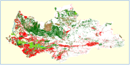
Fig. 7. FAO Land Use map of Harirud River Basin [5]
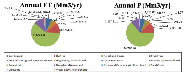
Fig. 8. Contribution of the land covers classes to annual precipitation (P) and actual evapotranspiration (ET) of the Harirud River Basin for the hydrological year 2014.
Table 2
The land use description, Precipitation, Actual Evapotranspiration and Interception for each land cover class from 0ct-2013 to sep-2014 in the Harirud River Basin
|
LAND USE |
INPUT | ||||||||||||
|
Lu _ va |
Lu _ description |
lu_area_km2 |
P |
ET act |
ET0 |
Root zone |
T |
I |
E |
Agri |
Envi |
Eco |
ET0 / P |
|
(mm/yr) |
(mm/yr) |
(mm/yr) |
(m) |
(%) |
(%) |
(%) |
(%) |
(%) |
(%) |
(-) | |||
|
1 |
Barren Land |
5513.88 |
220 |
176 |
0 |
0.5 |
0 |
0 |
100 |
0 |
100 |
0 |
0.032 |
|
2 |
Built-up |
303.44 |
258 |
195 |
0 |
0.5 |
25 |
5 |
70 |
0 |
0 |
100 |
0.643 |
|
3 |
Forest and Shrubs |
2059.59 |
339 |
148 |
0 |
2 |
80 |
15 |
5 |
40 |
40 |
20 |
0.072 |
|
4 |
Fruit Trees |
29.72 |
295 |
208 |
0 |
1 |
60 |
5 |
35 |
40 |
20 |
40 |
6.999 |
|
5 |
Fruit Trees/Irrigated Agricultural Land |
9.96 |
327 |
208 |
0 |
0.8 |
70 |
10 |
20 |
40 |
20 |
40 |
20.884 |
|
6 |
Irrigated Agricultural Land |
3008.36 |
263 |
211 |
0 |
0.8 |
65 |
10 |
25 |
40 |
20 |
40 |
0.070 |
|
7 |
Permanent Snow |
19.33 |
343 |
286 |
0 |
0.1 |
0 |
0 |
100 |
0 |
100 |
0 |
14.796 |
|
8 |
Rainfed Agricultural Land |
10293.8 |
278 |
152 |
0 |
1 |
55 |
5 |
40 |
40 |
20 |
40 |
0.015 |
|
9 |
Rangeland |
46099.34 |
310 |
183 |
0 |
0.7 |
50 |
5 |
45 |
40 |
50 |
10 |
0.004 |
|
10 |
Rangeland/Barren Land |
8761.91 |
244 |
182 |
0 |
0.8 |
30 |
0 |
70 |
20 |
70 |
10 |
0.021 |
|
11 |
Rangeland/Rain fed Agricultural Land |
136.57 |
292 |
206 |
0 |
0.6 |
60 |
5 |
35 |
40 |
50 |
10 |
1.508 |
|
12 |
Sand Cover |
28.94 |
231 |
160 |
0 |
0.4 |
0 |
0 |
100 |
0 |
100 |
0 |
5.529 |
|
13 |
Vineyards |
95.7 |
252 |
271 |
0 |
0.9 |
70 |
5 |
25 |
40 |
20 |
40 |
2.832 |
|
14 |
Water Body and Marshland |
1177.41 |
252 |
187 |
0 |
0.3 |
20 |
0 |
80 |
0 |
60 |
40 |
0.159 |
Table 3
The total precipitation (P) and actual evapotranspiration and interception (ETa) from WaPOR data for each land cover class for the Harirud River Basin for hydrological year 2014
|
RESULTS | |||||||
|
ET0 / P |
ET green/P |
ET green max |
ET green |
ET blue |
P |
ET |
P-ET |
|
(-) |
(-) |
(mm/yr) |
(mm/yr) |
(mm/yr) |
(Mm3/yr) |
(Mm3/yr) |
(Mm3/yr) |
|
6.59 |
0.99 |
218.18 |
176.00 |
0.00 |
1,213.05 |
970.44 |
242.61 |
|
5.62 |
0.99 |
254.85 |
195.00 |
0.00 |
78.29 |
59.17 |
19.12 |
|
4.28 |
0.98 |
330.63 |
148.00 |
0.00 |
698.20 |
304.82 |
393.38 |
|
4.91 |
0.98 |
289.92 |
208.00 |
0.00 |
8.77 |
6.18 |
2.59 |
|
4.43 |
0.98 |
319.65 |
208.00 |
0.00 |
3.26 |
2.07 |
1.19 |
|
5.51 |
0.99 |
259.63 |
211.00 |
0.00 |
791.20 |
634.76 |
156.43 |
|
4.23 |
0.97 |
334.27 |
286.00 |
0.00 |
6.63 |
5.53 |
1.10 |
|
5.21 |
0.99 |
273.89 |
152.00 |
0.00 |
2,861.68 |
1,564.66 |
1,297.02 |
|
4.68 |
0.98 |
303.93 |
183.00 |
0.00 |
14,290.80 |
8,436.18 |
5,854.62 |
|
5.94 |
0.99 |
241.40 |
182.00 |
0.00 |
2,137.91 |
1,594.67 |
543.24 |
|
4.96 |
0.98 |
287.11 |
206.00 |
0.00 |
39.88 |
28.13 |
11.75 |
|
6.27 |
0.99 |
228.85 |
160.00 |
0.00 |
6.69 |
4.63 |
2.05 |
|
5.75 |
0.99 |
249.09 |
249.09 |
21.91 |
24.12 |
25.93 |
-1.82 |
|
5.75 |
0.99 |
249.09 |
187.00 |
0.00 |
296.71 |
220.18 |
76.53 |
|
TOTAL |
22,457.16 |
13,857.36 |
8,599.80 | ||||
Table 4
|
RESULTS | |||||||
|
T |
I |
E |
Beneficial |
Non-beneficial |
Agriculture |
Environment |
Economy |
|
(Mm3/yr) |
(Mm3/yr) |
(Mm3/yr) |
(Mm3/yr) |
(Mm3/yr) |
(Mm3/yr) |
(Mm3/yr) |
(Mm3/yr) |
|
0.00 |
0.00 |
970.44 |
0.00 |
970.44 |
0.00 |
0.00 |
0.00 |
|
14.79 |
2.96 |
41.42 |
14.79 |
44.38 |
0.00 |
0.00 |
14.79 |
|
243.86 |
45.72 |
15.24 |
243.86 |
60.96 |
97.54 |
97.54 |
48.77 |
|
3.71 |
0.31 |
2.16 |
3.71 |
2.47 |
1.48 |
0.74 |
1.48 |
|
1.45 |
0.21 |
0.41 |
1.45 |
0.62 |
0.58 |
0.29 |
0.58 |
|
412.60 |
63.48 |
158.69 |
412.60 |
222.17 |
165.04 |
82.52 |
165.04 |
|
0.00 |
0.00 |
5.53 |
0.00 |
5.53 |
0.00 |
0.00 |
0.00 |
|
860.56 |
78.23 |
625.86 |
860.56 |
704.10 |
344.22 |
172.11 |
344.22 |
|
4,218.09 |
421.81 |
3,796.28 |
4,218.09 |
4,218.09 |
1,687.24 |
2,109.04 |
421.81 |
|
478.40 |
0.00 |
1,116.27 |
478.40 |
1,116.27 |
95.68 |
334.88 |
47.84 |
|
16.88 |
1.41 |
9.85 |
16.88 |
11.25 |
6.75 |
8.44 |
1.69 |
|
0.00 |
0.00 |
4.63 |
0.00 |
4.63 |
0.00 |
0.00 |
0.00 |
|
18.15 |
1.30 |
6.48 |
18.15 |
7.78 |
7.26 |
3.63 |
7.26 |
|
44.04 |
0.00 |
176.14 |
220.18 |
0.00 |
0.00 |
132.11 |
88.07 |
|
13,857.36 |
6,488.67 |
7,368.69 |
2,405.80 |
2,941.31 |
1,141.56 | ||
The key indicators result data for each land cover class of the Harirud River Basin for hydrological year 2014
At the river basin scale, the Resource Base Sheet (WA+ Sheet 1) offers a general overview of over-exploitation, unmanageable, manageable, exploitable, reserved, utilized, and utilizable flows. The figure 9 shows resource base of the Harirud River Basin in 2014. Water accounting for the Harirud River Basin was carried out for one water year of Oct 2013- Sep 2014. WA+ sheet was prepared for Harirud River Basin area. The WA+ results for these areas will be presented separately in this section. The entire Harirud Murghab River Basin was the focus of the basin level analysis. The total outflow from this region was used to determine the reservoir's total inflow. According to table 3, total precipitation in the year 2013–2014 was 22,457.16 Mm3/year, with an estimated 13857.35 Mm3/year recycled from evapotranspiration in the basin and a net water consumption of 8,599.80 Mm3/year. As table 4 presents the key indicators result data for each land cover class, this result helps to understand management options. The partitioning of ET into Evaporation (E), Transpiration (T), and Interception (I) can be seen on the right side of the table 4. In broad sense, this step outlines ET management principles in order to distinguish between beneficial and non-beneficial contributions to water consumption. According to the table 4, the basin's total evapotranspiration is 13,857.36 Mm3/year, with 6,488.67 Mm3/year of beneficial evapotranspiration and 7,368.69 Mm3/year of non-beneficial evapotranspiration. Consequently, the beneficial water distributed contributions of water consumption to agriculture, environment, and economy. Overall, WA+ will be used to infer key performance indicators in river basin management, which will be utilized to report to a country's highest political levels.
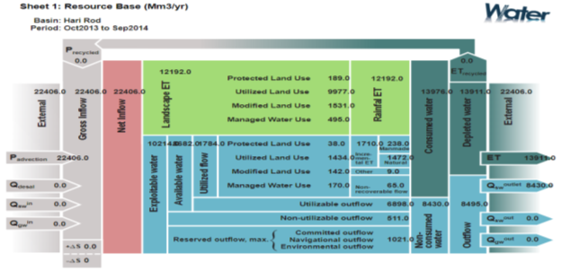
Fig. 9.Example of a Yearly WA+ Resource Base Sheet. The numbers are not meaningful and are merely meant to show the type of data that are included in the reporting
- Conclusion
The aim of the Water Accounting study was to conduct balanced analyses of the water accounts for the Basin, support irrigation designs, share data with governmental agencies, and inform water policymakers about the approach's benefits and drawbacks. This is in respect of the 2030 Agenda for Sustainable Growth, which includes not only supporting the shift to integrated water management in a sustainable manner and allocating water to high-productive sectors, but also supporting water resource planning and policy development, as well as informing water debates at the national and regional levels. The materials gathered are used for training and instruction at the region's and partner institutes. Water resource management issues in Afghanistan are complex, and a simple solution seems impossible. The article presented easily understandable conclusions as well as new data sets that can assist irrigation managers in improving their decision-making procedures. The study also describes the appropriate structure of the water accounting system for implementing and leading processes to plan and improve water accounting that meets the region's priorities, as well as providing answers to key questions posed by local and contextual challenges. The water accounts are useful for proving the WaPOR dataset's suitability for using the WA+ framework and closing the water balance. The findings of this study show that the WaPOR datasets can provide a spatial overview of where water is produced and consumed in the Harirud River Basin through ET, the largest water sink.
- Acknowledgments
This research was supported by the CAREC and Kazakh-German University as part of the student research competition on sustainable management of natural resources in Central Asia and Afghanistan (2020–2021). The author expresses gratitude to Larissa Kogutenko UNESCO Chair on IWRM at DKU for his continual support, guidance, motivation, and constructive criticism throughout the research. The author also expresses his sincere thanks to the MAIL and MEW of the Islamic Republic of Afghanistan for providing him the facility to access data. CDIS in cooperation with the United Nation Food and Agriculture Organization (FAO) conducted a water accounting study for the for Basins in Afghanistan, which I was one of the water accounting course participant. Some of this data i have collected from the water accounting course.
References:
- Favre, R., Kamal, G.M. (2004). Watershed Atlas of Afghanistan. 1st edition, Working Document for Planners, FAO and Afghanistan Information Management Agency (AIMS) . Retrieved from: http://aizon.org/watershed_atlas.htm
- Adhikary, S.K., Atef, S.S., Gupta, A.D., Babel, M.S., Clemente, R.S., and Perret, S.R. (2011). Potential Impacts of Incorporating EFR into Multi-Purpose Reservoir Operation Policy and Irrigation Management in the Hari Rod River Basin, Afghanistan. Journal of Engineering Science, 02(1&2), 41–48. Retrieved from: https://www.researchgate.net/figure/The-Hari-Rod-River-basin-in-Afghanistan_fig1_321759539.
- Ministry of Energy and Water, MEW. (2012). Western Basin Water Resources Management Project , Kabul, Afghanistan.
- Ministry of Energy and water, MEW. 2014. Harirud Master plan, provincial office , Herat, Afghanistan.
- Ministry of Agriculture, irrigation and livestock, MAIL, (2019). FAO, CDISP, Kabul, Afghanistan.
- Ministry of Energy, and Water, MEW, (2021), Cohesion projects department, Provincial office , Herat, Afghanistan.
- Moradi, M., Asadi, S., Shahbaz, H., (2017). A brief report of Urmia Lake Restoration Program.
- United States Agency for International Development (USAID). (2019). Situational Analysis for Basin Planning of the Lower Harirud River Basin in Afghanistan, Final report. Smart Waters Project.
- Ministry of Energy, and Water, MEW, (2021). Water resources department, Provincial office , Herat, Afghanistan.
- Bastiaanssen, W. G. M., Karimi, P., Rebelo, L.M., Duan, Z., Senay, G., Muthuwatte, L., Smakhtin, V. (2014). Earth observation based assessment of the water production and water consumption of Nile Basin agro-ecosystems . Remote Sensing . 6, 1030610334. https://doi.org/10.3390/rs61110306

