1. Introduction
Agricultural land is a key component of regional land resources, and its rational use depends on reliable information on area, structure, spatial distribution and change. State cadastral statistics provide the accounting basis for such assessment, while geographic information systems (GIS) make it possible to link these indicators with territorial units and visualize spatial differences [5, 7, 9, 10]. This is especially relevant for the Almaty Region, where arable land, irrigated areas, foothill agricultural zones and extensive pastures form a heterogeneous land-use structure.
In Kazakhstan, annual land-balance information is compiled from state land records, regional balances, cadastral data and land-monitoring materials [1–4]. Integrating these official indicators with administrative boundaries creates a practical basis for comparing districts and identifying changes that may be hidden in regional totals.
The aim of the study is to develop a geoinformation approach to cadastral monitoring of agricultural lands in the Almaty Region by combining official land-accounting indicators with spatial analysis. The objectives are to characterize the current land structure, assess reported dynamics and prepare a district-level cartographic basis for monitoring.
2. Materials and Methods
The Almaty Region is located in southeastern Kazakhstan and currently includes the Balkhash, Enbekshikazakh, Zhambyl, Ili, Karasai, Raiymbek, Talgar, Uyghur and Kegen districts. Current administrative boundaries are used so that statistical indicators and mapped territorial units are directly comparable.
The principal statistical source is the Consolidated Analytical Report on the State and Use of Lands of the Republic of Kazakhstan for 2024, prepared by the Committee for Land Management of the Ministry of Agriculture [1]. The study uses the total area of agricultural land, the composition of agricultural land-use areas and the reported long-term dynamics of the agricultural-land category.
Table 1
Reported dynamics of the agricultural-land category in the Almaty Region
|
Indicator |
1991 |
2005 |
2023 |
2024 |
Change 2024/1991 |
|
Agricultural land, million ha |
15.9 |
6.8 |
4.5 |
4.5 |
-11.4 |
Because the 2022 territorial reform changed the boundaries of the Almaty Region, pre-2022 and post-2022 values in Table 1 are not treated as directly comparable. The workflow includes four stages: standardization of annual land-balance indicators; preparation of district boundaries in a common coordinate reference system; joining statistical attributes to district polygons; and calculation and cartographic visualization of absolute, relative and structural changes.
For the district-level map, pasture indicators are visualized by pie charts. The diagrams compare additional pasture allocated from reserve lands in 2022 with the remaining part of pasture secured for public grazing in 2023. All values are shown in thousand hectares, allowing direct comparison among districts.
3. Results
According to the official land balance as of 1 November 2024, agricultural land in the Almaty Region covered 4,522.1 thousand ha, of which 4,467.4 thousand ha were agricultural land-use areas [1]. The structure is strongly dominated by pastures, whereas arable land forms a smaller but economically important component.
Table 2
Structure of agricultural lands in the Almaty Region as of 1 November 2024
|
Land indicator |
Area, thousand ha |
Share of agricultural land-use area, % |
|
Total agricultural-land category |
4,522.1 |
– |
|
Agricultural land-use areas, total |
4,467.4 |
100.0 |
|
Arable land |
438.2 |
9.8 |
|
Perennial plantations |
18.7 |
0.4 |
|
Fallow land |
50.4 |
1.1 |
|
Hayfields |
61.6 |
1.4 |
|
Pastures |
3,898.5 |
87.3 |
Pastures account for approximately 87.3 % of agricultural land-use areas, while arable land represents about 9.8 % [1]. Perennial plantations, fallow land and hayfields together occupy a relatively small share. These proportions show that cadastral monitoring should cover not only cropland but also extensive pasture resources.
District-level analysis is therefore the key scale for converting land-balance statistics into a practical monitoring tool. The map covers all nine current districts and uses the same territorial units as the accompanying statistics, allowing spatial differences to be identified consistently.
Figure 1 visualizes district-level pasture provision. The blue sector shows additional pasture allocated from reserve lands in 2022, while the orange sector shows the remaining secured pasture area within the 2023 total. The diagrams therefore represent composition rather than a direct year-to-year change.
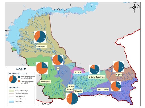
Fig. 1. District-level distribution of pasture indicators in the Almaty Region, 2022–2023
4. Discussion
The results confirm the value of combining official cadastral statistics with GIS-based spatial representation. Land-balance reports provide standardized quantitative indicators, while GIS reveals territorial differentiation and makes district comparisons more transparent [5, 7, 9, 10]. This is important because regional totals may conceal contrasting local patterns.
The predominance of pasture land indicates that monitoring focused only on arable land would describe only a limited part of the agricultural land fund [1]. A more complete system should distinguish arable land, pastures, hayfields, fallow land and perennial plantations and track both absolute area and structural shares.
Temporal analysis must account for administrative comparability. The 2022 territorial reform changed the basis of the Almaty Region statistics, so part of the apparent long-term decline reflects boundary change rather than land-use transformation [1, 2]. Historical regional series and operational district-level monitoring should therefore be interpreted separately.
Linking cadastral polygons, annual land-balance indicators and remote-sensing products in a single geodatabase can move monitoring from static reporting toward a spatially traceable system [5–7, 10, 11]. Its practical advantage is the ability to localize changes and identify districts or land parcels requiring additional inspection.
5. Conclusion
A GIS-based cadastral monitoring framework was developed for agricultural lands of the Almaty Region using official land-accounting data and district-level spatial analysis. In 2024, agricultural land covered 4,522.1 thousand ha; pastures dominated the agricultural land-use structure, while arable land accounted for about one tenth of the total.
The study shows that reliable temporal assessment requires stable territorial units and harmonized indicators. Combining cadastral statistics with GIS visualization provides a clearer basis for identifying local differences, interpreting land-use dynamics and supporting regional land-management decisions.
References:
- Ministry of Agriculture of the Republic of Kazakhstan, Committee for Land Management. Consolidated Analytical Report on the State and Use of Lands of the Republic of Kazakhstan for 2024. Astana, 2025.
- Ministry of Agriculture of the Republic of Kazakhstan, Committee for Land Management. Consolidated Analytical Report on the State and Use of Lands of the Republic of Kazakhstan for 2023. Astana, 2024.
- Republic of Kazakhstan. Land Code of the Republic of Kazakhstan. Code No. 442, 20 June 2003, as amended.
- Ministry of Agriculture of the Republic of Kazakhstan. Rules for Organizing and Conducting Monitoring of Agricultural Land Use. Order No. 252, 3 July 2019, registration No. 18997, as amended.
- Bennett R. M., van Oosterom P., Lemmen C., Koeva M. Remote Sensing for Land Administration. Remote Sensing. 2020;12(15):2497. DOI: 10.3390/rs12152497.
- Weiss M., Jacob F., Duveiller G. Remote sensing for agricultural applications: A meta-review. Remote Sensing of Environment. 2020;236:111402. DOI: 10.1016/j.rse.2019.111402.
- Lemmen C., van Oosterom P. J. M., Bennett R. M. The Land Administration Domain Model. Land Use Policy. 2015;49:535–545. DOI: 10.1016/j.landusepol.2015.01.014.
- Kearney S. P., Porensky L. M., Augustine D. J., Gaffney R., Derner J. D. Monitoring standing herbaceous biomass and thresholds in semiarid rangelands from harmonized Landsat 8 and Sentinel-2 imagery. Remote Sensing of Environment. 2022;271:112907. DOI: 10.1016/j.rse.2022.112907.
- Bennett R. M., Koeva M., Asiama K. Review of Remote Sensing for Land Administration: Origins, Debates, and Selected Cases. Remote Sensing. 2021;13(21):4198. DOI: 10.3390/rs13214198.
- Koeva M., Bennett R., Persello C. Remote Sensing for Land Administration 2.0. Remote Sensing. 2022;14(17):4359. DOI: 10.3390/rs14174359.
- Phiri D., Simwanda M., Salekin S., Nyirenda V. R., Murayama Y. Sentinel-2 Data for Land Cover/Use Mapping: A Review. Remote Sensing. 2020;12(14):2291. DOI: 10.3390/rs12142291.