Нижнекурская депрессия считается западным структурным элементом Южно-Каспийской впадины и ограничена Западно-Каспийскими тектоническими разломами на западе и юго-западе, глубинными разломами Аджичай-Алат на севере и северо-востоке и Западно-Абшеронскими разломами на востоке. Нижнекурский нефтегазоносный район образует юго-восточную часть Курской межгорной депрессии, расположенной между Большим и Малым Кавказом и Талышскими горными системами. Он граничит с Шамахи-Гобустанским и Саатли-Гойчайским нефтегазоносными районами на северо-востоке и северо-западе, Джалилабадским перспективным нефтегазоносным районом на юго-западе и Южно-Каспийской депрессией на юго-востоке. В статье с учетом особенностей палеотектонического развития исследуются перспективы Бандованского месторождения, входящего в Нижнекурский нефтегазоносный район.
Ключевые слова : депрессия, структуры, палеопрофиль, тектоника, анализ, период, продуктивная толща.
Introduction
LKD is a long-exploited and well-studied area of Azerbaijan by geological and geophysical exploration methods. Tectonically, the LKD is a buried depression extending toward all-Caucasus. The effect of compressional stresses arising here has led to the compression of rheologically active masses and the formation of uplifts in the submeridional direction (Fig. 1).
Prospecting and drilling works have been carried out since the beginning of the last century, and in recent times intense exploitation has been carried out. As a result of the geological-geophysical survey and drilling works 22 structures have been discovered here. The oil and gas-bearing some of them have been confirmed, and already exploited. They are Kurovdagh, Karabakhly, Kursangi, Mishovdagh, Neftchala, Galmaz, Kalamaddin folds. İn addition, promising structures such as Bandovan, Khidirli, Padar, which require more detailed research, are also a great interest.
Data and Methods
Recently, the Lower Kura Depression was considered an internal part of the Kura Intermontane Depression. New seismic and well data obtained since the 1960s indicate that the Lower Kura Depression is generally a northwestern continuation of the South Caspian Depression. This is confirmed by the similarity of the tectonics, lithostratigraphy, geological development history, and characteristics of the manifestation of mud volcanoes of both the South Caspian and the Lower Kura Depression.
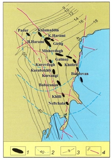
Fig. 1. The location scheme of the structures in the Lower Kura Depression
Legends: 1— structures, 2 — top of the Mesozoic age, 3 — isohypses, 4 — faults
In order to study the structural-tectonic development of the area, the paleodevelopment of the Bandovan structure was carried out based on the analysis of the constructed corresponding paleoprofiles. This plays a major role in obtaining accurate information about both its geological structure and oil and gas prospects. Paleoprofiles constructed based on the transverse profiles of the Bandovan fold, which is located along the Kalamaddin-Mishovdagh-Bandovan anticline zone, cover the Pontic-Quaternary stratigraphic interval. Based on these analyses, the study of the structural-tectonic development parameters of the Bandovan structure allows us to provide fairly accurate information about the oil and gas prospects of the fold.
Dimentions of the structure by the top of Lower Productive Series are 18 km in length, and 5–6 km in width.
This anticlinal fold, extending in the south-southeast direction, is separated from the Galmaz anticline by a wide and deep saddle. The fold is complicated by two faults, the fault planes of which lie at an angle of 75–80 o , parallel to the axis of the fold. Longitudinal faults, passing through the arch part of the southwestern limb of the fold, continue along the fold and create a fault zone with a width of 450–600 m. To the northeast of this zone, the arch and northeastern limb of the fold are located.
As can be seen from the paleoprofile constructed by the ends of the Pontic stage for the Bandovan fold, the development of its began earlier and continued under different tectonic conditions during the Pontic period (Figure 2).
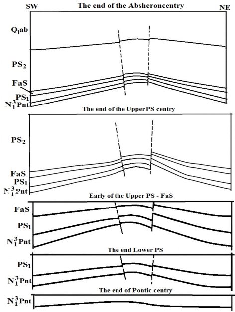
Fig. 2. Bandovan structure. Paleoprofiles
Thus, starting from the end of this period, the formation of the fold limbs and the process of sedimentation are simultaneously traced along with the development of the fold. The fact that the process of sedimentation occurred intensively in both the southwestern and northeastern limbs is indicate of positive tectonic movements in the arch of the fold. As a result, the sedimentation process in the arch of the fold was significantly weakened and slowed down.
The continuation of the increasing intensity of tectonic movements resulted in the formation of two faults that complicated the arch part of the fold at the end of the Lower Productive Series (PS) period. At this time, the intensity of the sedimentation process was different in the arch and limb parts: the sedimentation process in the arch part was weak, and in limbs it was more intense, although different.
It should be noted that the fold developed simultaneously with the sedimentation process in the Lower PS half-century. In this period, the development rate of the fold was relatively high, unlike before. The formed faults have been complicated the fold and the greater thickness of the accumulated sediments indicates that the development rate of the fold was relatively weaker than the sedimentation rate in the Lower PS period than in the Pontic century.
The paleoprofile reflecting the early of the Upper PS and the formation of the Fasila suite indicate that the rate of sedimentation in this half-century was significantly weaker than in the Lower PS. The faults that complicate the arch of the fold, passing through both the southwestern and northeastern limbs, due to the intensity of tectonic movements increased during this period. It should be noted that the height of the fold was approximately 300 m during this period.
The paleoprofile compiled for the end of the Upper PS half-century shows that the intensity of the formation of the fold increased even more. As a result of the high intensity, the thickness of the layers in the arch part of the structure is less than the limbs. At the same time, the thickness of the layers decreases towards the arch and wedging out.
At the end of the Upper PS century, the faults that further complicated the arch part of the fold caused its southwestern limb to break and fall lower relative to the arch. The disruption of the wholeness of the layers that make up the fold, the formation of faults led to the formation of traps of various types around them. The subsidence of the southwestern limb of the fold, and the breaking down of the northeastern limb relative to the arch, continues in the Absheron century.
In the paleoprofile constructed for the end of the Absheron century, the limbs of the fold rise in the northeast direction and take a stepped shape, in accordance with the characteristics of tectonic development. As a result, the formation of a small-amplitude reverse fault is observed in the southwestern limb, and a normal fault in the northeastern limb. Analysis of the paleoprofile reflecting this time period allows that the process of sedimentation and the development of the fold occurred simultaneously and with the same intensity in the southwestern and northeastern limbs of the fold.
Paleoanalyses show that the development of the fold occurred in active and continuous tectonic conditions. The complexity of the structure with normal and reverse faults indicated the active manifestation of compressional stresses in this region.
Conclusıon
- The widespread manifestation of mud volcanoes in the Lower Kura Depression is one of the factors that positively affects the geotectonic development of the OGR, oil and gas prospects and the formation of hydrocarbon fields.
- The occurrence of mud volcanoes in the territory of Azerbaijan is associated with the activity of compressional stresses, which lead to the complecation of structures with normal and reverse faults and the formation of stepped blocks.
- The intensity of the resulting compressional stresses caused the compression of rheologically active masses and the formation of folds in the submeridional direction.
- It is clear from the paleoprofiles compiled for the Galmaz and Bandovan structures formed in the Lower Kura Depression indicate that they are under the compressional stresses, resulting tormation of normal, revers faults in the structure, and also thrust faults.
References:
- Huseynov B. B., Salmanov A. M., Maharramov B. I. Oil and gas geological zoning onshore of Azerbaijan. Baku, Mars Print Publishing House, 2019, 310 p.
- Maharramov B. I. Geology of the Langebiz-Alat and Lower Kura Depression and their boundary zone. Baku, Mars Print Publishing House, 2023, 256 p.
- Salmanov A. M., Suleymanov A. M., Maharramov B. I. Paleogeology of oil and gas-bearing regions of Azerbaijan. Baku, ed. “Mars Print”, 2015, 472 p.
- Salmanov A. M., Maharramov B. I., Garagezov E.Sh., Kerimov N. S. Geology and indicators of oil and gas field development onshore territory of Azerbaijan, Handbook, Baku, MSV MMC Publishing House, 2023, 622 p.
- Мухтарова Х. З., Насибова Г. Д. Геологическое строение и перспективы нефтегазоносности глубокозалегающих горизонтов площади Мишовдаг Нижнекуринской впадины по новым геолого-геофизическим данным. Известия Уральского Государственного Горного Университета, Екатеринбург: Урал: 2016. № 4 (44), с. 18–24.

