Teleseismic source inversion methods have been used to investigate the rupture processes of the 2000 Sultandağ and 2002 Çay-Eber earthquakes, focusing on Western Turkey. By contextualizing the region's seismic activity through an extensive literature review, the study highlights the significance of teleseismic analyses. The methodology section provides detailed explanations of the data collection process, seismic network configurations, and advanced inversion techniques applied. The analyses reveal differences in the rupture processes and characteristics of the two earthquakes. A comparison of the results offers valuable insights into the seismotectonic structure of Western Turkey. The study not only deepens our understanding of these specific events but also provides important implications for seismic hazard assessment and risk mitigation strategies in the region. This study underscores the critical role of teleseismic source analyses in understanding earthquake dynamics and serves as a guide for future research in seismology.
Keywords: teleseismic source inversion, 2000 Sultandag earthquake, 2002 Çay-Eber earthquake.
- Introduction
Subject of Research
Seismic source inverse solutions play a crucial role in understanding the seismic source, fault mechanisms, and fracture dynamics, providing detailed insights that are essential for analyzing earthquakes like the 2000 Sultandağı and 2002 Eber events. These solutions help assess seismic hazards in the region and analyze the behavior of active fault systems. Here’s why seismic source applications are important for these specific earthquakes:
December 15, 2000 Sultandağı Earthquake: This earthquake occurred along the Sultandağ-Akşehir fault zone in Western Anatolia. Seismic source inverse solutions assist in determining the fault mechanism (whether the faulting is normal, reverse, or strike-slip) and the geometry of the fault plane. For the 2000 Sultandağı earthquake, inverse solutions likely identified it as a normal faulting event consistent with regional extensional tectonics. Understanding the stress regime in this context provides crucial insights into how the fault behaves under tectonic forces.
February 3, 2002 Çay-Eber Earthquake: Similar to the Sultandağı earthquake, the 2002 Çay-Eber earthquake also involved a significant fault system, and seismic source inverse solutions contributed to identifying the fault type and the direction of rupture propagation. This is important because the tectonic stress regime may change, and precise fault parameters are key to predicting future seismic hazards. In both cases, seismic source inverse solutions are vital for understanding fault dynamics and assessing seismic risks in the region.
Purpose of the research
Seismic source inverse solution applications provide critical data on how seismic rupture propagates along the fault plane during an earthquake. In both the 2000 Sultandağı and 2002 Eber earthquakes, these techniques likely offered insights into the rupture length, slip distribution, and how energy was released along the fault during the events. This information is valuable for understanding which sections of the fault moved, how much displacement occurred at different points, and where energy concentrated, which can influence future seismic activity in nearby fault sections. For example, the Sultandağı earthquake, though moderate in size, provided valuable information on whether the rupture propagated unilaterally or bilaterally and how this might have affected the damage distribution in surrounding areas. One of the key advantages of seismic source inverse solutions is their ability to provide information about the depth of the earthquake rupture. In the cases of both the Sultandağı and Çay-Eber earthquakes, seismic applications helped determine that these were shallow earthquakes (likely occurring at depths of less than 10 km), allowing for a more detailed examination of the resulting damage in both events. Additionally, these applications assist in calculating seismic moment, improving our understanding of the total energy released during the earthquakes. The data obtained can be compared with local strong motion records to refine hazard assessments for future events. After large earthquakes, seismic applications also help in understanding stress changes and the potential triggering of aftershocks or nearby fault activity (Alptekin, Ö., Barka, A.A., Nalbant, S.S., 1996).
For instance, after the 2000 Sultandağı earthquake, seismic applications could have been used to predict stress transfer to nearby faults, potentially forecasting the 2002 Eber earthquake. In both events, mapping the slip distribution and comparing it with aftershock activity can help us understand which sections of the fault remain locked and could generate future earthquakes. Both the 2000 Sultandağı and 2002 Eber earthquakes occurred in a tectonically complex region where the Anatolian Plate is undergoing extension. Seismic source inverse solutions contribute to a broader understanding of how the region’s normal fault systems behave, how stress accumulates and is released, and how the regional tectonic environment has evolved.
The data obtained from these applications can be incorporated into larger tectonic models, helping researchers assess the overall seismic risk of the region and identify which fault segments are most likely to produce future earthquakes. Therefore, conducting seismic source inversions for the 2000 Sultandağı and 2002 Eber earthquakes provides valuable information not only about the region’s tectonics in general but also about the specific segments of the Sultandağı-Akşehir Fault Zone where these earthquakes occurred. Seismic source applications have been essential in providing detailed data on the earthquakes' characteristics, fault mechanisms, and rupture behavior. By utilizing these tools, seismologists can gain important insights into focal mechanisms, slip distribution, and energy release, which are crucial for seismic hazard assessments and mitigation strategies in Turkey’s high seismic risk areas.
1.2 Seismotectonics of the Study Area
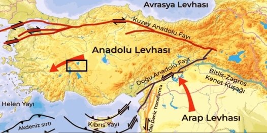
Western Turkey is located at the convergence of the Anatolian, Eurasian, and African plates, making it one of the most seismically active regions in the world (Alptekin, 1978; Jackson and McKenzie, 1984). This tectonic setting, driven by the movement of these plates and regional extension forces, creates significant seismic hazards. The region's seismic activity is primarily associated with the North Anatolian Fault (NAF) and various normal fault systems, making Western Turkey prone to frequent and sometimes destructive earthquakes. Lake Akşehir is located at the junction of the Anatolian and Arabian plates. On the map (Fig.1.), this location is situated in an area with high seismic activity, influenced by the tectonic boundaries in the region.

Fig. 1. Location of Lake Akşehir marked on the map of Anatolia and the Arabian plate
Key Factors Behind Seismic Activity in Western Turkey:
– Movement of the Anatolian Plate: The Anatolian Plate is pushed westward due to the convergence of the Eurasian Plate to the north and the African Plate to the south. This tectonic movement creates high stress along fault systems, leading to frequent earthquakes in Western Turkey.
– Aegean Extension (Extensional Tectonics): Western Turkey, particularly the Aegean region, undergoes significant extension due to tectonic forces that separate the Earth's crust. This leads to the development of numerous normal fault systems, causing shallow earthquakes that can result in significant damage to infrastructure and buildings.
– Subduction of the African Plate: In addition to the extensional regime, the African Plate is subducting beneath the Aegean region along the Hellenic Arc, contributing to seismic activity. Subduction zones often cause large earthquakes, further increasing seismic hazards in Western Turkey.
1.2 Teleseismic Source İnversion of 2000–2002 Earthquakes
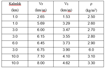
The teleseismic point-source modeling utilized the one-dimensional crustal velocity model proposed by Thurber (1983).
Table 1
The crustal velocity structure used in the inversion was adapted from Thurber (1983). S-wave velocities were determined using the Vp/Vs = 1.73 ratio.

Here, Vp: P-wave velocity; Vs: S-wave velocity; ρ: density.
Teleseismic Point-Source Inversion of the December 15, 2000 Sultandağ Earthquake
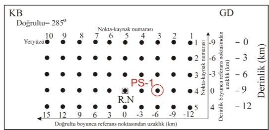
Synthetic seismogram calculations utilized 128 sampling points with a 0.5-second sampling interval. The earthquake source was represented by a point-source grid consisting of 10 points along strike and 5 along dip, distributed at 3 km intervals. This grid defined a rupture area of 27x12 km², oriented at 285°. The reference point was selected at a depth of 9 km, with its surface projection corresponding to the earthquake's epicenter. After initial inversion trials, the reference point was identified as the point source in the 3 rd row along strike and the 4 th row along dip. The final configuration of the point-source grid is illustrated in Figure 1.2. Synthetic seismograms were calculated using a trapezoidal source time function with a total duration of 4 seconds, including 1-second rise and fall times. A rupture velocity of 3.0 km/s was assumed.

Fig. 2. The point-source grid plane model used in the point-source inversion of the December 15, 2000 Sultandağ Earthquake is illustrated, with the reference point (RN) highlighted in a square. The red circle labeled PS-1 indicates the location of the point source determined by the inversion
Teleseismic Point-Source Inversion of the February 3, 2002 Çay-Eber Earthquake
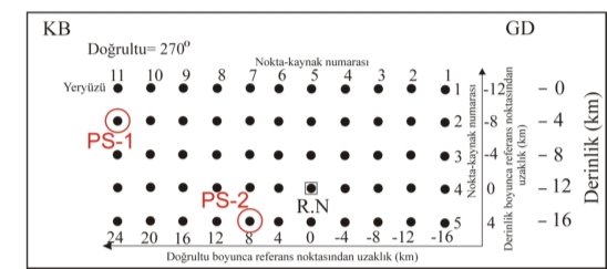
For the calculation of synthetic seismograms, 128 sampling points with a 0.5-second sampling interval were used. The earthquake source was represented by a regularly spaced point-source grid, with 11 point sources along the strike and 5 along the dip, distributed at 4 km intervals. This allowed for the inversion of an earthquake rupture measuring 40 km in length and 16 km in width. The grid's strike direction was set to 295°, and the reference point was chosen at a depth of 12 km. The surface projection of the reference point corresponds to the determined epicenter of the earthquake. Initial inversions identified the reference point as the 5th point along the strike and the 4th along the dip. The constructed point-source grid is illustrated in Figure 1.3. A trapezoidal source time function with a total duration of 4 seconds (1-second rise and fall times) was used. The rupture velocity was assumed to be 3.0 km/s.

Fig. 3. The point source grid plane model used for the point source inversion of the February 3, 2002 Çay-Eber earthquake is shown. The reference point (RN) selected as the point source is highlighted with a square. Red circles labeled PS-1 and PS-2 indicate the locations of point sources determined by the inversion
Conclusion
In this study, point-source inversions for the December 15, 2000 Sultandağ and February 3, 2002 Çay-Eber earthquakes were performed using broadband P-waveforms recorded at teleseismic distances. The method developed by Kikuchi and Kanamori (1982, 1991) was applied for the point-source inversion. The results obtained from the inversions provide valuable insights into the rupture processes of both earthquakes. The small point-source obtained from the 2002 Çay-Eber earthquake inversion, which is predominantly reverse faulting, coincides with reverse faults that cut through the ancient sediments between the Çay and Sultandağ districts. This alignment demonstrates the consistency of the reverse faulting character identified from the inversion with field observations.
References:
- Alptekin, Ö. Magnitude-frequency relationships and deformation release for the earthquakes in and around Turkey. Diss. Thesis for Promoting to Associate Professor Level. Karadeniz Technical University, 107 pp.(in Turkish), 1978.
- JACKSON, James; MCKENZIE, Dan. Active tectonics of the Alpine—Himalayan Belt between western Turkey and Pakistan. Geophysical Journal International, 1984, 77.1: 185–264.
- Kikuchi, Masayuki, and Hiroo Kanamori. «Inversion of complex body waves». Bulletin of the Seismological Society of America 72.2 (1982): 491–506.
- Kikuchi, Masayuki, and Hiroo Kanamori. «Inversion of complex body waves—III». Bulletin of the Seismological Society of America 81.6 (1991): 2335–2350.
- Nalbant, Süleyman S., A. Aykut Barka, and Ömer Alptekin. «Failure stress change caused by the 1992 Erzincan earthquake (Ms= 6.8)». Geophysical research letters 23.13 (1996): 1561–1564.
- Thurber, C.H., 1983. Earthquake locations and three-dimensional crustal structure in Coyota Lake area, central California., J. Geophys. Res., 88, 8226–8236.

