The use of GIS technology in the prevention of natural disasters | Статья в журнале «Молодой ученый»

Отправьте статью сегодня! Журнал выйдет 30 ноября, печатный экземпляр отправим 4 декабря.

Опубликовать статью в журнале

Библиографическое описание:

Рахматов, С. С. The use of GIS technology in the prevention of natural disasters / С. С. Рахматов, Т. Ш. Бобоназаров, О. М. Абдурахмонов, С. Н. Ядгаров. — Текст : непосредственный // Молодой ученый. — 2022. — № 5 (400). — С. 12-15. — URL: https://moluch.ru/archive/400/88645/ (дата обращения: 16.11.2024).


In this article, we will consider one method of using Geoinformation technology in disaster prevention. We use QGIS software as an example for theme lighting. Through this program, we analyze where a lot of natural disasters occur, the causes of their occurrence, when they occur and how much damage they cause.

Key word s: QGIS, landslide, flood, natural disaster.

В этой статье мы рассмотрим один из способов использования геоинформационных технологий для предотвращения стихийных бедствий. Чтобы осветить тему, мы будем использовать программу QGIS в качестве примера. С помощью этой программы мы анализируем, где происходят многие стихийные бедствия, причины их возникновения, когда они происходят и какой ущерб они наносят.

Ключевые слова: QGIS, оползень, наводнение, стихийное бедствие.

Every year in Uzbekistan, natural disasters affect an average of 1.4 million people, causing damage of about 3 billion dollars. This was stated in a round table held on November 22 in conjunction with the World Bank and the regional environmental center of Central Asia by the Ministry of Economic Development and poverty reduction. [1]

GIS uses many industries that use geographical reference data. On the other hand, any natural disaster is a spatial representation that can change its temporal location. Wildfires, floods, and landslides can be mapped as a polygon. Natural resources, forests (natural elements), roads and rural areas (such as irregularities) are covered in these areas. This information can be useful for digital computer systems such as Geographic Information Systems (GIS). Presents a discussion on the use of GIS for disaster management. [7]

A natural disaster is a change in the supernatural that occurs in nature, it is sudden, a change in the speed of people, a violation of working conditions,the growth of people, as well as those that end with the extinction of rural animals, material wealth. There are different types of natural disasters: land silage, floods, strong wind, floods, construction, landslides, etc. It is carried out in Tashkent (50 times), Kashkadarya (20 times) and Fergana (17 times) regions of the extra-budgetary pension fund under the Ministry of Finance of the Republic of Uzbekistan. For example, on March 25 of last year, as a result of acquaintance with the cargo carrier «Kamaz — 5320" of the Russian car «Neksiya» in 1298 kilometers of the Tashkent — Termez highway in the Kashkadarya Region, 4 people were sacrificed and 1 person was hospitalized. On 23 May in Urgut district, two avtoulovs were shot dead 6 people died and 5 people died. Over the past period in our republic 39 times there was a situation with natural processes, as a result of which 60 people died, 138 were injured. [2]

One of the natural disasters that pose a great danger to the population and objects of national economy, which live in the mountainous, mountainous, river regions of the Republic, is Earth power. The regions where the avalanches may occur include Tashkent, Andijan, Fergana, Samarkand, Surkhandarya, Kashkadarya, as well as some districts of Jizzakh and Namangan regions. Every year 150–250 avalanches occur in our republic. Under the influence of gravity, the thrust of rocks along the mountain slope is called Landslide. Landslides can occur as a result of water washing of the mountain slope, an increase in the slope, a decrease in the strength of rocks due to the influence of winds or moistening of precipitation and groundwater, the influence of seismic vibrations and the impact of economic activity carried out by man without taking into account the geological conditions of the place. 90 % of landslides occur in the mountains, at an altitude of 1000–1700 m.On account of the loosening of the rocks of the mountains under the influence of wind blowing (radiation), surface and groundwater activities, mainly on the steep falling and jargon mountain slopes, river valleys and sea coasts, large masses and disruption of mountain rocks are called landslides. [3]

We mark these areas with high avalanche risks in the QGIS program(figure 1).
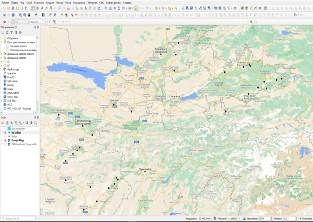
Fig. 1. Areas where there is a risk of landslides in Uzbekistan

A flood is a temporary flow of water with a strong current, that is, a large amount of stone, sand and other solid materials, forming a flood in the mountain rivers themselves. Rapid melting of strong and continuous precipitation, snow and glaciers is the cause for the occurrence of flooding. The size of some stones and springs cross-3–4 m.ga enough. As soon as the flood hits the barrier, it will exceed them and become more powerful. We will do this by defining the areas with high risk of landslides in the QGIS program (figure 2).
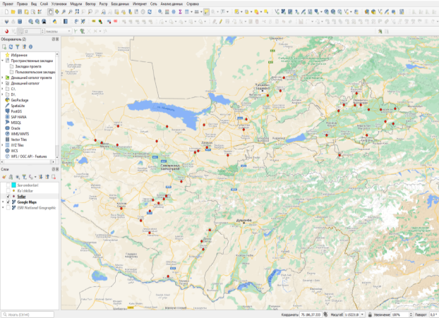
Fig. 2. Areas where there is a risk of flooding in Uzbekistan

This can be done by entering as much data as we want into the specified regions(points) and analyzing it.

If we enter information about the natural phenomena that occur at each point in the general year cross-section. This will help us to determine the cycle of recurrence in how many years natural phenomena occur, and in the future to know the recurrence of this natural phenomenon. We can develop protective measures depending on the type of incident if we know approximately how many repetitions this event will occur.

In conclusion, we can say that the integration of Geoinformation systems with different sectors into a period in which the current development is growing will lead to a significant development of this sector. Therefore, I think that the use of Geoinformation systems in the Prevention of natural disasters also gives its benefits. In addition, we can widely use Geoinformation systems in our field, that is, in the road sector. We have witnessed a lot of this, and we can say that these programs contribute greatly to the rapid development of the industry. This is quite effective in the application of GIS technologies in the territory of Uzbekistan.

References:

  1. 747-сон 25.11.2020. Tabiiy ofatlar oqibatida aholiga yetkazilgan zararni qoplash tartibi to‘g‘risidagi nizomni tasdiqlash haqida (lex.uz).
  2. Kuzatiladigan tabiiy оfatlar va ularning оqibatlari. Rеja (hozir.org).
  3. Ko`chki, sel va o`pirilishlar» GeoOlamga xush kelibsiz! (geografiya.uz).
  4. Sel haqida tushuncha. Reja (hozir.org).
  5. Sodikov Zh. Electronic accounting of traffic accidents with the use of geoinformation technologies / / Bulletin of the Tashkent Institute of Railway Transport. 2017. No. 2.
  6. Sodikov J. Visualization of accidents using Google Fusion Tables / / Vestnik TADI. 2017. No. 2.
  7. https://www.researchgate.net/publication/345179571_Geographical_Information_System_GIS_for_Disaster_Management.
Основные термины (генерируются автоматически): QGIS, GIS, TADI.


Ключевые слова

QGIS, landslide, flood, natural disaster

Похожие статьи

Drilling strategies in cracked formations

Significant volumes of hydrocarbons are found in naturally fractured reservoirs, especially in fields abandoned due to inadequate testing and assessment or because wells did not intersect fractures. Work in one may fail miserably in another. Conseque...

Balancing maintenance of gas and gas condensate wells

The wells serve as channels connected to the layer to regulate the processes occurring in the hearth. As a result of the well test, monitoring for the indicators obtains information about the process of their exploitation in oil and gas wells and abo...

The theory of the process of deformation of the river itself

At present, the intensive development of hydraulic engineering construction, not only in our country around the world, has caused the need to take into account the impact of various structures on channel processes, especially on flat rivers. The stud...

The use of innovative methods in education

The article presents the types and benefits of interactive methods, as a form of innovative learning. Also, an algorithm for conducting an interactive lesson is presented, and also features of carrying out its main part are stated. The features of ca...

The problems of mining ecology

This article is devoted to negative impacts of mining industry to the environment, specifically discussed geological and geometrical features of the mine, affect of chemical elements, technical and technological processes as well.

Information technology «Innovative development of science»

This article discusses how to properly educate and develop the future generation to achieve better learning outcomes across the country. As we know, youth is the future of our state, which means that all efforts and all attention must be paid to yout...

Pattern and image recognition with neural networks

The most popular application of neural networks is visual image recognition. Today, networks are being created in which machines can successfully identify symbols on paper and bank cards, signatures on official documents and objects. These functions ...

Road planning in Syrian desert using geographical information system and the least cost path approach

In this research, effort has been made to introduce a method with GIS and Least Cost Path capability for planning road. So that environmental factors such as stability are incorporated in the planning process. After collection of data and the necessa...

Monetizing programming skills, or How to build a Business with a laptop in hands

Given the development of the availability of the Internet and computer technology in general, the demand for specialists who are able to create and maintain websites in working condition has sharply increased. This is due to the fact that people's pr...

The role of innovative techniques in teaching English

“There is nothing permanent except change,” says Heraclites, the pre Aristotelian Greek philosopher. Change is the law of nature. With a number of educational options available before the present generation learners, the newer methods and techniques ...

Задать вопрос