Introduction
Water is the core of sustainable development and the cornerstone of economies, societies, and cultures. As a substance with no substitute and a crucial driver of development, it has importance to all actors, including households, farmers, entrepreneurs, politicians, environmentalists, scientists, and sometimes even terrorists. However, freshwater resources are limited and unevenly distributed. Alongside these variabilities, weak capacity of institutions, adverse impacts of climate change, and population growth created significant water challenges and incentives for conflicts among actors and even sometimes posed security threats (Gleick 2014; Wolf 2007) [1].
While water challenges are persisting, the solutions highly depend on the conscious decisions and actions towards the water at multiple levels of government and across the sectors (OECD, 2018). Now, the important questions need to be answered as who do what, why and when, which are important to know about the levels also, are they at the national, or local levels? (Akhmouch, Clavreul, & Glas, 2018). Thus, Water Governance as the practice of coordination and decision making becomes central, and the efficiency, effectiveness, inclusiveness, transparency, and predictability of decisions highly depend on the robustness of the water governance system (Zwarteveen et al 2017) [2].
Sustainable Water Management is critical to Afghanistan's stability, economic growth, and poverty reduction efforts. Afghanistan has relatively abundant renewable surface water resources — estimated around 57 billion cubic meters each year (Mahmoodi, 2008). However, it has one of the lowest storage capacities in the world estimated at 80 m3/capita/year (Thomas, 2016b). Only around 63 percent of the population has access to improved drinking water sources, and only around 36 percent of the population using safely managed drinking water services (CSO 2018) [3].
Also, the country's economy is primarily based on agriculture that (licit agriculture) contributes 32 % to the country’s Gross Domestic Product (GDP), where more than 80 % of its people’s income depends on agrarian activities (GIRoA, 2012; Sinfield & Shroder, 2016). However, due to the shortage of irrigation and water infrastructures, the inefficiency of existing infrastructures, and inadequate institutional capacity, only 1.8 million ha out of total 7.8 million ha of arable lands are under cultivation, 44 percent of the population is facing food insecurity, and 27 percent of the population is facing food insecure very severely (Mahmoodi 2008; Sinfield & Shroder 2016; Thomas 2016b) [4].
The total flow of the Amu Darya River from all sources is about 79 km 3 per year, which in 1960, before so much water was extracted for irrigation, kept the Aral Sea as the world’s fourth largest lake in reasonably good health and level. The average annual flow of the Amu Darya from Tajikistan is 49.6 km3 or 63 % of total flow, and from Afghanistan is 17.0 km 3 , or 22 % of total flow, all of which comes from the Panj-Amu basin (most of the river water is distributing to the canals or desert at the Northern basin in Afghanistan before joining to Amu Darya River). In wet years the flow from Afghanistan may be as high as 24 km 3 , but as little as 14 km 3 in drought years (Centre for Afghanistan Studies, University of Nebraska Omaha, US) [5].
Furthermore, Afghanistan is on the top of the list among countries that are vulnerable to climate change in the world, particularly concerning droughts and floods (Thomas, 2016a; UNEP, 2014). Besides being a drought-sensitive country, climate change is shrinking its water resources rapidly, causing prolonged droughts that made traditional farming difficult. Even many people (primarily farmers) have been forced to leave their farms or cultivate drought-resistant crops such as poppy and opium (Iqbal, Donjadee, Kwanyuen, & Liu, 2018; Shroder, 2016b, 2016d). Similarly, flooding patterns and intensities are also becoming very severe due to climate change that takes hundreds of lives yearly and creates costly damages (Shroder 2016b) [6].
Afghanistan is not a wet country; it is dry country as the summer time is a very important period for the irrigation to receive enough water, and the on other hand the snowfall is happening during the winter time and part of that is storing on mountains and start melting from early spring and produce water downstream mainly for irrigation and other water users. Still, we have traditional irrigations practices which could reduce the water efficiency, would be possible to be considered on changes of technologies for irrigation systems to increase the water efficiency. Afghanistan has different types of lands which are single or double crop lands, the double crop lands are mainly located in the location which has a warmer spring and summer with enough water availability. Also, ren-fed area has a good role and takes part for producing agricultural productions. (Water Resources Sector Assessment Report, Asian Development Bank 2015) [7].
Location
The Panj-Amu basin is one of five river basins in Afghanistan. It is part of the Amu Darya basin which itself is part of the larger Aral Sea basin which covers Kazakhstan, Uzbekistan, Tajikistan, Afghanistan, Turkmenistan, and to a lesser extent China and Pakistan. The agricultural production is very high in the Panj-Amu basin which is clear for the whole country, also this basin has good potential for producing hydropower. There are plans to build dams/reservoirs for storing the water and producing electricity, but it is not implemented yet. Mainly the extraction of water that diverts the flow on irrigation lands is located at the downstream and middle part of the basin. Mainly the canals are uncontrolled and unlined, but recently some works and new infrastructures have been implemented and completed. Still, the most focus of the government was managing water for irrigation purposes, that works need to be done on other parts also, such as on controlling floods, providing water for urban, watershed management, environment protection, and rural water management (LML, P-ARBP, 2019) [8].
Physical characteristics of the Panj-Amu river basin, it drains from North Eastern and has its headwater, where it starts as the Wakhan and then Panj River, in the Pamir Mountains (along the Wakhan corridor), but a large part of the basin is part of the northern plains, it delineated from south part by mountains called Hindu Kush, and in the North by the Panj and Amu Darya Rivers (the Panj River is named Amu Darya River after the confluence of the Panj with the Kofernikhan, Kunduz, and Vaksh rivers), forming the northern border of Afghanistan with Tajikistan and Uzbekistan. The estimated total area of this basin is about 97,000 km2 (Watershed Atlas of Afghanistan 2004) [9].
Overview of Panj-Amu Basin
Afghanistan has 5 river basins which Panj-Amu is the second basin based on the size of the area, the estimated population in this basin is 4.2 million water availability per capita is 4250 m3/year (UNFAO, 2016. LCA, 2015) [10]. But the water availability for the irrigation lands inside the basin is not always available as it changes and the tail of the basin experience water shortage during the late warm period of the year, in fact, the right amount of water should be available in the right time for water users in the basin. The irrigation land as the irrigated area within the basin is estimated 450,000 ha (World Bank, Afghanistan Agricultural Sector Review 2014) [11], but almost all of this 420,000ha is intensively irrigated areas comprising almost a quarter of the total intensively irrigated land (second only to the much larger Helmand basin).
This river basin is the largest rice and wheat producer in Afghanistan as produced 1.28 million tons of wheat and 263 000 tons of rice in the year 2015 (Government of Afghanistan 2015) [12]. There is a high potential for the diversification of crops, fruits, vegetables, and crops for the industry. It is the highest producer of pears, peaches, sugar beet, canola, sesame, and watermelon and the second highest producer of walnuts, plums, chilies, onions, potatoes, carrots, and melon. Moreover, non-traditional crops such as lemons and soybeans and being introduced to the area. The important factor is development to keep this basin sustainable by producing huge number of agricultural products and high-quality fruits (LM, PARBP 2012) [13].
As a decentralized department of the Ministry of Energy and Water is the River Basin Agencies in Afghanistan, one of them is the Panj-Amu river basin. The basins have a responsibility to manage the water and produce plans within their basins. The Panj-Amu river basin is divided into 6 sub-river basin agencies which each sub-basin needs to report and coordinate with the main River Basin Agency.
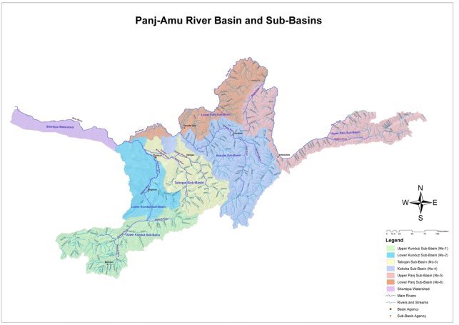
Figure 1: Panj-Amu River Basin and Sub-River Basins (LM, P-ARBP 2019) [14]
River Basin Organizations
The institutional framework for water resources planning and management is set out in the Water Law, 2009. Following enactment of the Water Law, and the above approved procedures, MEW and the provincial water management departments were restructured to enable better implementation of IWRM. The restructuring started in 2011 and is still ongoing, and is based on the following institutional set-up (LM, P-ARBP 2019) [14].
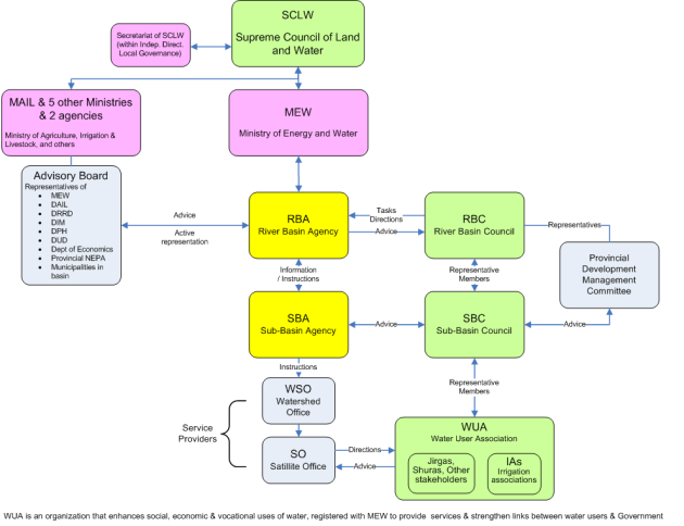
Figure 2: Institutional set up for water resources management (LM, P-ARBP 2019) [14]
Decisions on water resource planning options and water management issues are to be made by the basin (or sub-basin) community representatives meeting at a river basin (or sub-basin) council (RBC/SBC), based on information provided by River Basin Agency (RBA) and Sub Basin Agencies (SBAs). Decisions are then implemented by the RBA and SBAs (LM, P-ARBP 2019) [14].
The river basin management structure in the Panj-Amu Basin consists of an RBA in Kunduz, and an SBA in each sub-basin as follows:
a) Upper Kunduz sub-basin (Bamyan)
b) Lower Kunduz sub-basin (Baghlan)
c) Taloqan sub-basin (Taloqan)
d) Kokcha sub-basin (Faizabad)
e) Lower Panj sub-basin (Dasht e Qala)
f) Upper Panj sub-basin (Ishkashim)
Taloqan Sub-River Basin
Taloqan sub-river basin is one of the most important basins among the other 5 sub-basins of the Panj-Amu River Basin. One of the important tributaries of Amu River is located in the Taloqan sub-river basin which is called the Taloqan River. The area of this basin is about 13,000 km 2 which many canals and irrigation lands located in this basin. One of the largest canals is the Shahrawan Canal which its length is 82 km with command area of 12,953 ha (LM, P-ARBP 2019) [14]. Taloqan sub-river basin produces a lot of agricultural products which provides food for the outside of the main basin too. Fortunately, this important basin was covered under different Governmental or Non-governmental projects, we have a huge number of infrastructures constructed on the rivers to manage and regulate the water, but still, it needs more construction and improvement to have a proper water allocation and distribution among all water users. In this basin, we have 6 automatic gauging stations installed on main tributaries.
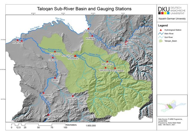
Note: the below schematic map of Taloqan-Sub River Basin which shows the main rivers tributaries, canals and installed gauging stations.
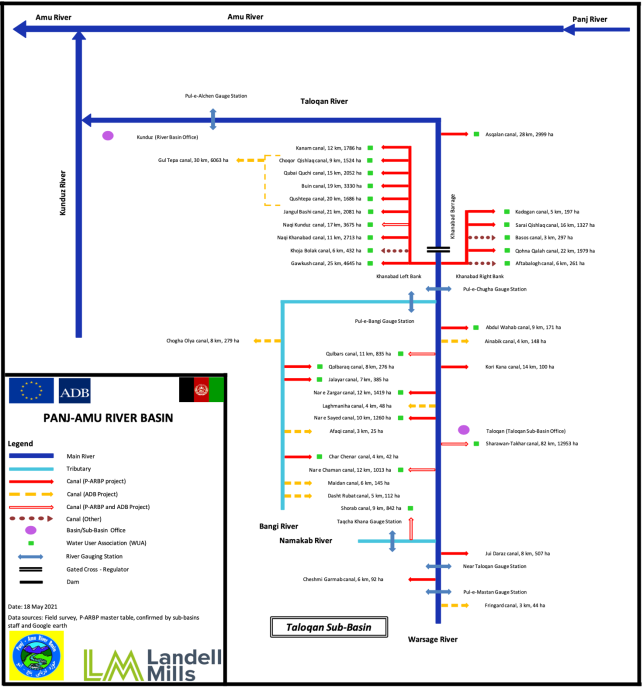
Figure 4: The schematic of Taloqan River Basin (LM, P-ARBP 2019) [14]
Literature review
Water management in river basin
The runoff has a direct relationship with the precipitation, and it depends on the amount of snowfall in wintertime and rainfall during the warm season (April to September), we could see the high variability during the summertime as we experience the peak flow in June or July. The climate change impacts and increase of air temperature would shift the peak flow earlier and more variability is seen during the warm-season, also increase of mean flow during the cold-season as instead of having more snow during the cold-season will experience rainfall. The changes in flow, snow, and glaciers would be a message for us that the impacts of global warming need adaptation on the ground. It requires actions to be taken by the water management organizations to increase the efficiency of water usage as it is expected to have a shortage of water during the warm-season especially at the end of this season as the stored snow would be less, it melts faster, and cannot produce water for the whole warm-season period.
In the last decades, it is recommended to have an Integrated Water Resources Management approach and all the management should be based on the delineated basin area to achieve good water resources management at the end. Also, decentralization of managing water is an important point to involve all from the local water users to the national level, involving the water user’s association is a key participatory approach needs to be involved them (UN 1992; Lee and Dinar, WB 1993; 1996; Solanes, 1998) [15]. Studies of management in river basins help to have a clear understanding of the management of integrated resources based on the outcome and implementation approaches (Anjali Bhat, William Blomquist 2004) [16].
The climate change impacts, increasing of the population, limitation of the resources requires good planning and management in all parts of the world. Using from the resources and based on that making plans how to be shared the resources could have impacts on the ground as have an example of Aral see which is dying (Micklin, P. 1988) [17]. Water conservation has linked with the improved physical efficiency of the water that how the water is using the fraction is applied, to enhance the economic efficiency it requires a broader concept, by involving the physical and managerial measures we could seek the economic value of the water usages (Ximing Cai, Mark W. Rosegrant 2003) [18]. As a sub-set of Integrated Water Resources Management, IRBM is regarded as an integrated and coordinated approach for planning and managing water resources in a basin, it would encourage the stakeholders to consider a wide range of social and environmental interconnections in a catchment/watershed context (Hooper, B. 2005) [19].
Glacial Shrinkage and Retreat
Recently the climate change has affected the Amu river basin’s glaciers. The glaciers melt faster due to warming climate, also the recent significant drought years of 1998–2001, the total annual river discharge shown less than 42 km3 in the Pnaj-Amu River Basin compared to the average flow which is between 64 and 70 km3. Afghanistan’s glaciers decreased by 50 % during the last 50 years. This component of the mass water balance of the basin, therefore, plays a vital role and is essential in buffering the river discharge in years of low winter and spring precipitation. Although total annual precipitation is not predicted to change significantly in the long term, the volume of runoff from the mountains and its seasonal distribution may change considerably (Anonymous, https://lance.modaps.eosdis.nasa.gov/im). Snow and glacial are the main sources to produce water in the Amu river basin, so snow and glacial melt are important to get enough water downstream. Large amounts of water are stored as snow (during the wintertime) and ice in the mountains of this basin. Changes in temperature and precipitation are expected that could have significant effects on resources and on snow and ice storage. This mountainous in the basin will be impacted by changes in climate in different ways (Immerzeel, W. W. 2012) [20].
Water Management for Agriculture in a Sustainable Way
To have sustainable water management for agriculture requires a balance between the amount of available water and needs considering both quality and quantity. Providing enough water at the right time for agriculture is the main important issue to keep the productivities sustainable and also safe the environment. To adapt this based on the current environmental impacts, we would need to involve few important parts, technologies, the behavior of social, rural communities, institutional frameworks, economic constraints, and agricultural practices (Konstantinos Chartzoulakisa*, Maria Bertaki 2014) [21].
Water requirement for irrigation is the amount of water that is necessary for crops to grow excluding the precipitation and soil moisture, and enough water to have production. The quantity of water is the full water that is required such as water use as consumptive, paddy field extra water, water for protecting plants from salinization, which allows the plants to grow (Mohammad Valipour 2016) [22].
Methodology
To achieve the listed objectives, firstly need to start with collecting the necessary data such as flow data from the installed gauging stations we have inside the river basin, also we need to collect the meteorological data, information on existing hydraulic infrastructures, current water management, and main water consumers. Then analyses of hydrometeorological data for the basin area (recorded flow data from the gauging stations, air temperature, and precipitations) will make this possible to see the changes of flow during the recorded period, considering the climate change issue and link them on how the water management is adapted on the ground based on that results. Besides this, we need to apply mapping through using ArcGIS/QGIS to identify canals, command area, gauging stations, this would help us to know how the current water allocation and distribution between each gauging station are going on. Having interviews with the related organization who are responsible for water management in the basin such as RBA, SBA, and WUAs will help us to have a clear understanding of the current situation on water management, and could accelerate to identify the challenges in this regard. Also, using questionnaires will help this study to be more strengthened as it would cover the agencies from the national and local levels, including the WUAs.
Finally, would achieve as the result, equitable water sharing among all users, improvement on water allocation and distribution, best practice based on the water availability at the source and water users, suggesting a technical solution to the government based on the variability of flow during the irrigation period, as this period is crucial for irrigation.
Hydrometeorological data
The daily mean flow data of the 6 functional gauging stations in the Taloqan river basin (Alchen Chogha, Bangi, Taqcha Khana, Near Taloqan, and Mastan) were collected from the Ministry of Energy and Water of Afghanistan.
Table 1
Taloqan gauging stations (MEW of Afghanistan 2019) [23]
|
Gauge Station Name |
Long. |
Lat. |
Elevation (m) |
Drainage Area (km 2 ) |
|
Alchen |
68.86278056 |
36.80419167 |
372 |
10406 |
|
Chogha |
69.19651944 |
36.72826667 |
550 |
9989 |
|
Bangi |
69.20813889 |
36.73037500 |
556 |
4465 |
|
Taqcha Khana |
69.70823333 |
36.53367222 |
1472 |
265 |
|
Near Taloqan |
69.73739444 |
36.63538330 |
1008 |
4142 |
|
Mastan |
69.97974722 |
36.32745556 |
1550 |
2918 |
The works are done on received hydrometeorological data in which the changes in discharge, precipitation, and air temperature could be seen. The discharge was plotted in different ways to have a more clear idea of changes of the data during the period of time and was linked with the precipitation and air temperature. The recent years especially the year 2019 discharge shows a high recorded discharge which the precipitation doesn’t show very high record that we have for the year 2019, therefore, there is a possibility of melting of the glaciers as it affected by the increases of the air temperature. The resources to produce water downstream mainly the glaciers and snow will be reduced in the next coming years if we do not have enough precipitation.
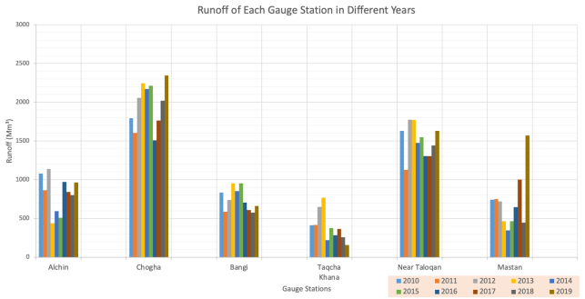
Figure 5: Runoff of each gauging station (MEW of Afghanistan 2019)
The green and gray color bar charts in the below chart are the important water gauges installed on the main Taloqan river. The Near Taloqan gauging station is located a bit upstream in compression with the Chogha gauging station, we have another inflow just upstream of the Chogha gauging station which is called Mastan gauge station, and joining with the Taloqan main river.
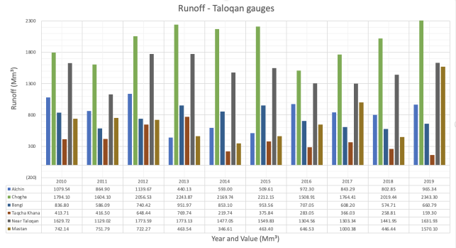
Figure 6: Runoff of each gauging station in a specific year
From the below charts, we can see that the water changes at the source are different at the different gauging stations, other gauges excluding the Taqcha khana which is located very upstream of the river basin on a branch sub-river shows flow increases for the year 2019.
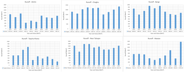
Figure 7: Changes of water during the different years for each gauging station
To have a clear picture of the changes of water during the months, the different years separately and also in group mode was plotted. Below you can see the monthly mean flow for a few years is shown for the Taloqan gauge station as an important gauge station that it is close to the Taloqan city and at upstream and downstream of this gauge station we have a huge number of canals. The peak discharge is during the months of June and July which is the temperature in also maximum and it melts a huge volume of the glaciers and snow from the resource.
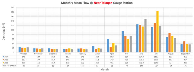
Figure 8: Monthly mean flow at Near Taloqan gauging station
The precipitation was involved during the analysis of the flow data which mostly have the precipitation during the cold season in winter that there is a four months delay when we have the peak flow during the summertime.
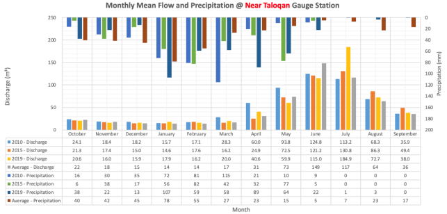
Figure 9: Monthly mean flow and precipitation at Near Taloqan gauging station
To have a closer view on precipitation and discharge for each gauging station, it was used to be plotted the gauging station data separately too. The below chart shows the precipitation and discharges for the Near Taloqan gauge station for the year 2019.
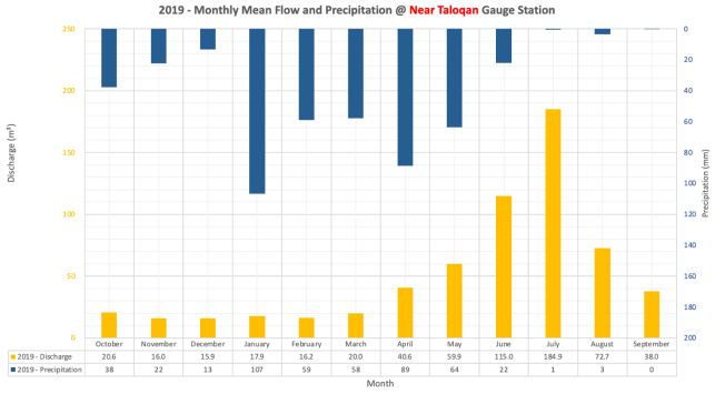
Figure 10: Monthly mean flow and precipitation at Near Taloqan gauging station for year 2019
The maximum and minimum flow helps to consider how the water is managing during that critical time, how the RBA/SBA allocates and distributes the water among all users which to do not have any conflicts. The peak flow for 2019 is happening in July, but based on the mean monthly flow, the peak flow is in June.
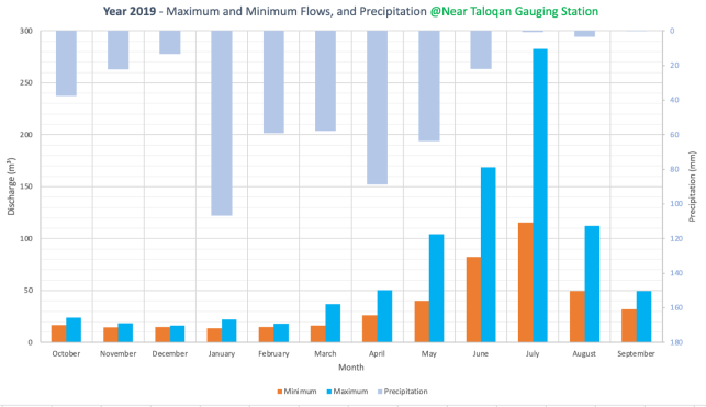
Figure 11: Maximum and Minimum flows, and Precipitation at Near Taloqan gauging station in 2019
As the recorded flow data for Taloqan gauging station show a high discharge for the year 2019, it is used to be checked second important and main gauge station that is that also shows a high recorded flow or not, as you can see the Chogha gauging station also show a high flow record for 2019. Usually, we need to compare a few gauging stations to make sure that the increases of flow at the upstream gauging station had affected the downstream station also, otherwise, there would be questions about the quality of the data.
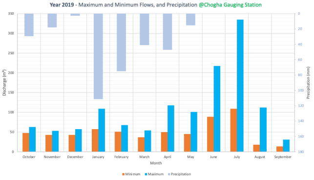
Figure 12: Maximum and Minimum flows, and Precipitation at Chogha gauging station in 2019
This air temperature is recorded by the Near Taloqan automatic gauging station as we the source of precipitation data was also the same gauging stations, it is used the one-month data to see the maximum, minimum and average air temperature.
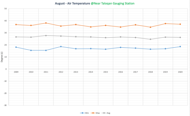
Figure 13: Minimum, Maximum and Average Air Temperature at Near Taloqan for month of August
Recommendation
To achieve good water management in the river basin, there must be considered a few important issues, first of all, the River Basin Agencies/Sub River Basin Agencies which are the main responsible organizations to manage the water in the river basin, need to analyze and see the water changes at the resources and rivers, then based on that bring adjustments or revisions on their plans on water distribution and allocations. The climate change impacts and changes on precipitations must be taken into account as the important elements for water management. The main water consumers and size of the irrigation lands including the types of crops which require a different amount of water should be under supervision and records of the River Basin Agencies, that to increase the water efficiency, changes the type of crops besides the irrigation technologies would have a key role. As its some of the general recommendations for the existing river basin and over all the countries basins are as follows;
Development to Afghanistan’s and regions; hydrometeorological expertise, establishment of a formal confidence building structure for Afghanistan and as co-riparian countries to share water policies, mobilizations of international support to move away from national water strategies and toward regional water strategies.
Conclusion
When the required hydrometeorological data (flow data, air temperature, precipitation), and other data and information about the main water users, command area of irrigation lands, existing infrastructures, role and responsibility of the RBA/SBA, and WUAs for the river basin collected, after analysis of these data and information it smoot the ways to identify the existing challenges based on the current water management which is applying in the river basin. The variability of discharge during the warm season as it is the crucial period to provide enough water for irrigation lands requires adaptation from the related organizations mainly RBA and SBAs to allocate and distribute the water based on the real water availability at the source. The climate change impacts need to be considered and based on that take some actions and planning to be up to date. We need to have a clear understanding of the amount of water which is using for different types of users including the environmental usages to keep the environmental systems safe, and then link them with the current water availability at the source and predicting the next year water situation based on the changes on different hydrometeorological parameters. These activities and study in this regard make the possibility to achieve our main goal which is equitable water sharing among all users, an improvement on water allocation and distribution, best practice based on the water availability at the source and water users, suggesting a technical solution to the government at the national and local level based on the variability of flow during the year.
References:
- Gleick, 2014; Wolf, 2007
- Zwarteveen et al., 2017
- CSO, 2018.
- Mahmoodi, 2008; Sinfield & Shroder, 2016; Thomas, 2016b
- Centre for Afghanistan Studies, University of Nebraska Omaha, US
- Shroder, 2016b
- Asian Development Bank, Water Resources Sector Assessment Report September 2015.
- LML, P-ARBP Final Report 2019.
- Watershed Atlas of Afghanistan, Kabul, January 2004.
- Food and Agriculture Organization of the United Nations. 2016. Rome, the Islamic Republic of Afghanistan: Land Cover Atlas 2015.
- World Bank, Afghanistan Agricultural Sector Review 2014.
- Government of Afghanistan. Ministry of Irrigation, Agriculture and Irrigation. Agricultural Year Book, 2015.
- LM, PARBP, Land Cover Atlas of Afghanistan 2012.
- Landell Mills, PARBP, Final Report, March 2019.
- United Nations, 1992; World Bank, 1993; Lee and Dinar, 1996; Solanes, 1998
- Anjali Bhat, William Blomquist, Policy, politics, and WM in the Guadalquivir RB, Spain, 16 July 2004.
- Micklin. P. Aral Sea dessication: WM disaster in the SU, Science, 241(4870) (1988).
- Ximing Cai, Mark W. Rosegrant, and Claudia Ringler, Physical and economic efficiency of water use in the river basin 2003.
- Hooper, B. Integrated River Basin Governance, London 2005
- Immerzeel, W. W., et al, 2012
- Konstantinos Chartzoulakisa and Maria Bertaki, SWM for agriculture under climate change. The Effects of Irrigation and Drainage on Rural and Urban Landscapes, Patras, Greece, IRLA2014
- Mohammad Valipour, how do different factors impact agricultural water management? October 31, 2016.
- Ministry of Energy and Water (MEW) of Afghanistan, Water Resources Department, annual water yearbook 2019.


