Hydropower development is highly affected by climate change and human development activities. Analyzing hydropower development trends that were conducted and finished in the past is important to understand past changes and predict future trends. Land surface pictures offer an alternative explanation of gaining insights into river dynamics. Here we use the latest versions of the Variable Infiltration Capacity (VIC) hydrological model to assess the impact of climate change on river discharges and hydropower potential in the Abbay River basin of Ethiopia. This study assessed the impact of climate change on hydropower potential in the Abbay River Basin of Ethiopia using a distributed hydrological model approach. The spatial changes of the water resources under three designed scenarios were analyzed and hydropower potential production prediction was calculated. VIC hydrological model was applied using runoff simulation after 1000 times of calibration and validation. However, the simulation has higher uncertainty in in the case of high flow and low flow scenarios. The results of this study indicated that, different degrees of future alterations in river discharge and the spatial and temporal distributions of water resources have to be expected, leading to an increase of in hydropower production potentials under the scenario of RCP2.6, RCP4.5 and RCP8.5.
Keywords: climate change, hydropower potential, vic model, Abbay river basin.
According to data from NASA, the global temperature in 2013 averaged 58.3 degrees Fahrenheit (14.6 degrees Celsius), roughly a degree warmer than the recorded twentieth-century average. Since the dawn of agriculture 11,000 years ago, civilization has enjoyed a relatively stable climate. That is now changing as the growing human population affects long-range geological processes that have serious impact in our planet. About 4 billion people residing today have never experienced a year that was cooler than last century's average, raising an interesting question of what is now considered “the normal” with respect to climate [1].
Based on reports of IPCC, global average temperature of sea and the land surface has increased beyond expectations over the past 100 years. This caused a surge in the height of sea level but decrease of snowfall and glaciers. Thus, global warming may threaten human life that causes the attack of extreme weather like heavy rainfall, heat waves, flooding, drought, hurricanes, windstorm etc. [2, 3].
Global land precipitation has increased since the beginning of the 20th century, however, the increase was neither spatially nor temporally uniform [4]. Climate change affects the hydrological cycle by changing the special and temporal availability of water resources. The impact of climate change on water resources is highly significant as humans and all natural ecosystems are heavily dependent on water.
According to FAO, Ethiopia is endowed with abundant water resources, but with very high hydrological variability due to different ecological systems. The country has huge potential of surface water resources. Ethiopia possesses twelve major river basins, including the Abbay or Blue Nile, Baro-Akobo, Setit-Tekeze/Atbara and Mereb, which altogether cover 33 % of the country that drains the northern and central parts in western areas. Climate change increases the number of people living in water stressed places, exacerbating the already existing challenges facing the people in the region. It changes precipitation, temperature, and stream flow of the Abbay river basin which is threatening the lives and livelihoods of the surrounding settled people [5].
Various studies showed that climate change will increase the number of people living in water stressed regions globally [6,7]. This impact is worse in Africa where about 25 % of the population have already experienced water stress. Considering population increase and water use, it is estimated that 65 % of the population will be at risk of water stress and scarcity by the year 2025. Climate change is expected to exacerbate the current water stress problems in Africa.
Researchers have developed model-based approach tor analyze the potential effects of global changes on Europe’s hydropower effect at a country scale. They found that severe future alterations in discharge regimes have to be expected, leading to unstable regional trends in Europe’s hydropower.
Previous studies have shown the influence of climate change and human activities on hydrological cycle traces and movements of rivers [8]. Renewable fresh water is the foundation of lives and ecosystems which support to terrestrial and freshwater bodies [7,8]. Thus, it is important to analyze the history of hydrological trends to predict and forecast future changes. The objective of this study is to build a VIC model in the Abbay River basin of Ethiopia and predict the spatial and temporal tendencies of water resources change in the future. On the basis of the predicted water resources, the hydropower potential under scenarios of RCP2.6, RCP4.5 and RCP8.5 were calculated. Bases on the results, some practical strategies were recommended to manage the negative impacts of climate change.
Materials and Methods
Study area
Ethiopia is endowed with rich and diverse natural resources. Water is considered as the most abundant natural resource in the country and is often named the ‘water roof or table of East Africa’. Ethiopia has started its strategy to exploit and make use of its huge water resources and promote economic growth.
The hydrological system of the country is divided into 12 major river basins. Out of which 8 are river basins, 1 lake basin, and the remaining 3 are dry basins. Among these river basins, Abay, Baro-akobo, Omo and Tekeze encompass 80–90 % of the country’s total surface water. Abay river basin is the most important and the second largest basin in the country. This study focused on the three tributes of Abbay River basin namely, Megech, Gilgel Abbay and Teme rivers.
Megech river (sub-basin)
The Megech watershed is located in the northern part of the Lake Tana sub-basin in the Amhara region of Ethiopia. It originates near the Simien Mountains at an altitude of around 4000 m above sea level. The total watershed is 663 km 2 and the lake inlet of 500 km 2 is gauged. The lake catchment lies between latitude 12°30'45" to 7°43'0' N, and longitude 37°21'34"-37°35'26«E. In 1997, a dam was constructed on the tributary of Megech River that supplies water to the town of Gondar. The reservoir has a surface area of 51 hectare (ha) and a design capacity of 5.3 Mm 3 with a catchment area of 68 km 2 (i.e., 13 % of the gauged). Eighty two percent of the catchment has slopes of more than 8 % increasing the vulnerability of erosion. Ninety five percent of the catchment is cropland and Eutric and Leptosols cover the rest of the area. In 2007, one-third of the volume of the reservoir was filled with sediment due to high soil erosion from the catchment.
Gilgel Abbay river (sub-basin)
Although there are several feeder streams that flow into Lake Tana, the sacred source of the river is generally considered to be a small spring og Gish Abay, situated at an elevation of approximately 2,744 meters (9,003 ft.). This stream, known as the Gilgel Abay (Lesser Abay River), flows north into Lake Tana. Other affluent of this lake include, in clockwise order from Gorgora, the Magech River, the Northern Gumara, the Reb River, the southern Gumara River, and the Kilte. Lake Tana flows about 30 kilometers (19 mi) before plunging into the Blue Nile Falls. The river then loops across northwest Ethiopia through a series of deep valleys and canyons into Sudan, at which point it is named the Blue Nile .
Temcha sub-basin
The Temcha sub-basin is located in the southern Gojam region. More than 70 % of the whole sub-basin is cultivated or used for pasture. The Temcha sub-basin has an average annual precipitation of 1680 mm, which is the highest of the whole Abbay River basin. However, the highest measured discharge peaks during the rainy season couldn’t be simulated with the available precipitation data. Generally, the basin is subdivided into 16 sub-basins based on the major rivers in the basin, the Abbay River, and its tributaries. (See Fig. 1 below).
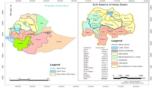
Fig. 1. Geographical Location of Abbay Basin
Data used in the study
The study used in this analysis is from the historically collected observation data and geographical information of Megech, Gilgel Abbay, and Temcha sub-basins. Historical patterns of hydrological and meteorological variables are an important basis for water resource development programs. This dataset becomes important as the rate of current land use and climate change increases [9]. Water resources are being exploited at an alarming rate in many areas of the world, including the Abbay River basin (199,592.17 km2) of Ethiopia (www.mowr.gov.et) [5]. The Abbay River basin delivers more than 60 % of the Nile River water to Aswan, Egypt. The basin is also home to more than 20 million inhabitants whose main livelihood is subsistence agriculture [10]. The hydrological records of the Abbay Basin form a key basis for dimensioning hydraulic structures such as dams, trans boundary negotiations about the sharing of the basin’s water resource [11], and the assessment of the sustainability of subsistence farming systems in the region. This farming is mainly dependent on rain, with some small-scale irrigation that uses the water of small streams. The subsistence farming is the main form of livelihood for 80 % of the population, and farming was increasing at an annual rate of 2.6 % in 1990–2000 [11]. Political change in relation to land management is believed to worsen the availability of water resources in the Abbay Basin [12–15]. The political change in 1974/1975 with the overthrow of the monarchy was accompanied by a ‘land to the tiller’ policy, where many previously uncultivated lands were allotted for cultivation. There was a nationwide resettlement program in the years 1984/1985 and another political regime change in 1991. After 1991, a new and more secure land tenure system called ‘rural land registration’’ was implemented [16]. The new land policy encouraged farmers to clear forests in some areas while planting trees in other areas, especially around homesteads [17]. The changes in land management policies caused degradation of soil, forest and other natural resources [16,18–20].
Based on the geographical information; the topography of the river is composed of highlands, hills, valleys, and some rock peaks. Most of the streams feeding the Abbay river basin are perennials. The average annual rainfall varies between 1200 and 1800 mm/yr. It ranges from an average of about 1000 mm/year near the Ethiopia/Sudan border to 1400 mm/yr in the upper part of the basin, and in excess of 1800 mm/yr in the South. Locally, the climatic seasons are defined as dry season (Bega) from October to the end of February; short rain period (Belg) from March to May; and long rainy period (Kiremt) from June to September, with the greatest rainfall occurring in July and August. The yearly variation in monthly rainfall is most pronounced in the dry season while the lowest annual variation occurring in the rainy season. Inter annual variability of rainfall in the basin is about 10 %.
Methodology
Description of VIC model
The variable infiltration capacity (VIC) model requires estimation of three parameters: an infiltration parameter, an evaporation parameter, and a base flow recession coefficient. The VIC model was explored through direct comparisons with the Geophysical Fluid Dynamics Laboratory (GFDL) bucket model for the French Broad River, North Carolina, and via sensitivity analysis of the GFDL R30 grid cell which contains the French Broad River. Generally, the bucket model runoff had much greater variability than the historic stream flows for short time scales (e.g., 1 day). In this respect, the VIC model was much more similar to the observed flows. The results also showed that the bucket model tended to have unrealistically high short-term variability. The sensitivity analysis showed that the base flow parameter exerted the greatest influence on both the mean and variability of most of the hydrologic variables, especially winter runoff and summer evaporation.
Rivers play a major role in the hydrology of the land surface over substantial areas of the globe but coherent information about their dynamics is largely lacking. The quality and completeness of information from in situ sources varies tremendously for different countries and regions. Recently, satellite data have provided some information about variations in lake surface elevation (from satellite altimeters) and surface extent (from visible and other sensors) for the largest lakes. Land surface models offer an alternative means of gaining insights into lake dynamics. Here we use a recent version of the Variable Infiltration Capacity (VIC) model, which includes a lake/wetland module, to simulate the 40-year (1960–2009) variations of lake level and surface area of the Abbay river basin.
Figure 2 shows the VIC model of the Abbay river basin. It is a grid-based macro scale distributed land surface hydrological model. Its grid characteristics facilitate its coupling with climate models to assess the impact of climate change on water resources. It was originally a one-layer model VIC-1L which was proposed by Wood et al. [21] according to the infiltration capacity of one layer of soil. On the basis of VIC-1L, Liang et al. [22] introduced the storage capacity curve of the Abbay model [23] and improved the model with a two-layer model VIC-2L. The model mainly considers the physical exchange processes and reflects the state change and transfer of water and heat among atmosphere, vegetation and soil. In order to strengthen the description of dynamic variation of soil moisture in the surface layer and diffusion process of soil moisture in soil layers, the model was improved in such a way that a 0.1m soil layer is separated from the upper soil layer. Thus, the model now has three layers of soil [24]. The VIC-3L model can consider different vegetation types including bare soil, and simultaneously taking into account water and energy balances. The model is further optimized using a method described by Liang et al. [23,24], a new runoff mechanism which can simultaneously consider Dunne and Horton runoff and sub-grids heterogeneity. Currently, the model is extensively applied to assess the impact of climate change on water resources [25–28].
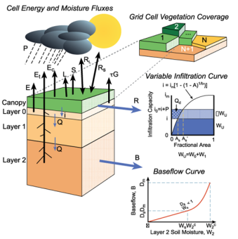
Fig. 2. VIC model
Accurate runoff simulation is very important for the assessment of the impact of climate change on water resources. In the VIC model, runoff is divided into surface runoff and base flow. Surface runoff, including Dunne and Horton runoff, only occurs in the top two layers. Whereas, the base flow, which is calculated by the ARNO model [29], generates in the lower layer. Then the runoff is assumed to flow into one of the eight grids adjacent to the grid and converge to the downstream grid. In the confluence scheme, overland flow concentration is realized by unit hydrograph method and channel concentration is calculated by linearized Saint-Venant equations [30].
Two types of parameters exist in the VIC model. The first type, including parameters related to vegetation types and soil properties, can be calibrated directly by their physical meaning. Due to the complexity of runoff production, the other type, which is closely related to hydrologic process is hard to obtain and needs to be calibrated by using observed hydrological data. These parameters are B, Dsmax, Ds, Ws, D2 and D3, respectively. B ranges from 0 to 0.6, which refers to variable infiltration curve parameter and means the inhomogeneity of spatial distribution of water content in each grid. The greater the value of B, the more uneven is the distribution. Dsmax ranges from 0 to 30, which is the maximum velocity of baseflow in the lower soil. Dsmax is influenced by the hydraulic conductivity of soil and means of the gradient of grids. Ds range from 0 to 1, which is the ratio of the base flow to Dsmax where non-linear base flow begins. Ws ranges from 0 to 1, which means the ratio of the soil moisture to the maximum soil moisture where non-linear base flow occurs. D2 and D3 range from 0.1 to 1.5, and mean the thickness of the second and third soil layer, respectively.
In order to assess the performance of the VIC model, Nash-Sutcliffe efficiency coefficient (NSE) is used to reflect the matching degree between the simulated runoff and observed runoff [31]. Relative error (BIAS) is employed to measure the average tendency of the difference between the simulated runoff and the observed runoff [32]. The formulas are shown as follows:


Where O i means the observed runoff, Si the simulated runoff, «O« ̅ the average observed runoff and N is the number of time steps.
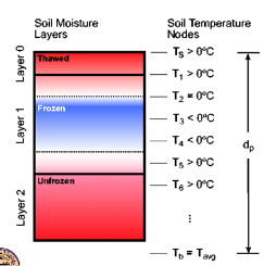
Fig. 3. The structure of the hydrological model
The vertical water flow in the topsoil is represented by Richards’ equation and is solved by an implicit numerical solution scheme. In this scheme, the topsoil is subdivided into a number of layers. Similar to the common subdivision used in many land surface schemes, the topsoil is divided into a near-surface layer of 5 cm, a root zone, and a deep zone. The root zone and deep zone are again derived into sublayers in the present model. The first layer is expected to be saturated during the rainfall period. Therefore, the upper boundary condition is given as constant soil water content for the rainfall cases. During the non-rainfall period, evaporation from the soil surface exists, and the upper boundary condition is given as a constant flux. The soil water distribution along the hillslope is treated as uniform. The surface runoff is from the infiltration excess and saturation excess calculated by solving Richards’ equation. The surface runoff flows through the hillslope into the stream via kinematic wave. The groundwater aquifer is treated as an individual storage corresponding to each grid.
The exchange between the groundwater and the river water is considered as steady flow and is calculated by Darcy’s law. The runoff generated from the grid is the lateral inflow into the river at the same flows interval, which were given as a certain proportion of the saturated hydraulic conductivity of the topsoil.
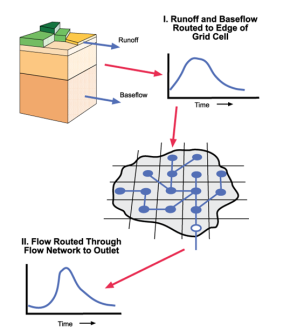
Fig. 4. Monthly discharge processes
Results and Discussion
Calibration and Validation
As shown in Table 1, there are two parameters in the VIC model, which is the hydraulic conductivity of the groundwater. According to the climate and landscape conditions, three sub basins were selected for the calibration. They represent the upstream area of the Megech river (sub-basin), the Gilgel Abbay river (sub-basin), and the Temcrha river (sub-basin) (see Figure 1).
Table 1
Simulation results of monthly discharge during calibration and validation periods in Abbay river basin. NSE and BIAS are two indicators to measure the simulation performance.
|
Stations |
Calibration Period |
Validation Period |
||
|
NSE |
BIAS |
NSE |
BIAS |
|
|
Megech Azezo near to Gonder |
0.79 |
13 % |
0.77 |
-19 % |
|
Gilgel Abbay near to Bahir Dar |
0.56 |
5 % |
0.68 |
11.3 % |
|
Teme near to Motta |
0.84 |
-15 % |
0.84 |
-24 % |
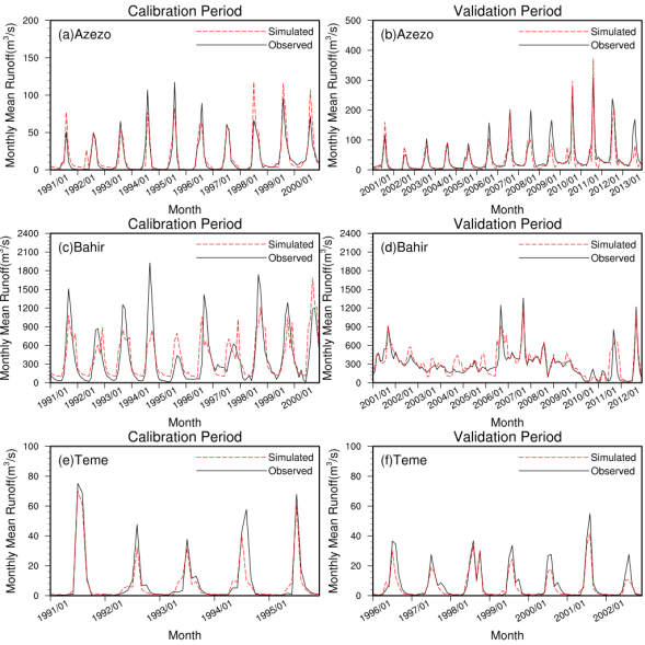
Fig. 5. Monthly mean runoff process: (a) (c) (e) calibration period (b) (d) (f) validation period
3.2. Spatial change in future water resources
In order to predict the water resources and the relative changes under the scenarios of RCP2.6, RCP4.5 and RCP8.5, for the periods of 1981- 2010 and 2021- 2050 set as baseline and future periods respectively. Figures 5 and 6 illustrate the spatial distribution of mean annual runoff depth output by VIC model driven by climate models under the scenarios of RCP2.6, RCP4.5 and RCP8.5. The three figures all show the GFDL-ESM2M model predicts the most runoff, and the mean annual runoff depth may exceed 1600 mm at the outlet. Although the runoff depths simulated by five climate models are different, the spatial distributions are similar. The difference may derive from the structure and parameterization schemes of the five climate models. In order to reduce the error between the five climate models, multi-model ensemble is used [33] and the ensemble results are treated as the future water resources.
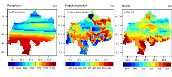
Fig. 6. Spatial distribution of mean annual precipitation, evaporation and runoff
Conclusions
A VIC hydrological model is used to assess the impact of climate change on river discharge and hydropower potential in the Abbay River basin of Ethiopia. In this study, the spatial changes of the water resources under three scenarios are analyzed and the hydropower potential in the future were calculated. Based on the results of the study, the following conclusions were drawn:
- The VIC model is applicable to modelling the runoff in the Abbay River basin. The values of NSE are all greater than 0.7 and those of BIAS are all no more than ±20 %. However, we only use the observed runoff data to calibrate the result, which may lead to the flood peak discharge. Thus, it is highly recommended that more observed data should be used in the future to calibrate the model and improve the accuracy of simulation performance.
2. The water resources in the future show different results by coupling with the five climate models. According to multi-model ensemble results, spatially, the mean annual runoff depth increases significantly in the northern mountainous area, modestly in the lower plain, and decreases in the middle reaches of the basin. Temporally, the mean annual runoff results show an increasing trend under the three scenarios. Particularly, under RCP4.5 scenario, the annual runoff is 25 %, 33.3 % and 10 % larger than during baseline period at Megech, Gilggel Abbay and Temcha sub-basin respectively. Although the mean monthly runoff decreases by more than 20 % in July under the three climate scenarios, in general, it shows an increasing trend.
3. The hydropower potential during baseline is 907.3×10⁶ kw·h, and it is 989.6×10⁶, 1049.2×106 and 977.6×10⁶ kw·h under RCP2.6, RCP4.5 and RCP8.5 scenarios respectively. Although, in general, it increases in the entire year, its percentage decreases during flood season. In order to develop and utilize the hydropower resources, cascade reservoirs imperative be constructed in the upper and middle reaches of the basin in the future.
In conclusion, considering the complexity of hydropower, we focused more on the river discharge to simplify the calculation of hydropower potential. The results of this study indicated that, different degrees of future alterations in river discharge and the spatial and temporal distributions of water resources have to be expected, leading to an increase of in hydropower potentials under the scenario of RCP2.6, RCP4.5 and RCP8.5. In order to accurately assess the impact of climate change on hydropower potential, a computable approach that combines models from climatology, hydrology, econometrics and operational research should be applied.
Funding: This study was funded by the National Key Research and Development Project of China (grant 2016YFA0601503).
Acknowledgments: The authors would like to thank the National Meteorological Service Agency of Ethiopia for providing the raw meteorological and hydrological data. We also thank the China Institute of Water Resources and Hydropower Research for financing this research.
References:
- Global Temperature. Warmest Decade on Record Brings Record Temperatures and Weather Extremes, Available online: http://www.earth-policy.org/indicators/C51/ (accessed on 04 February, 2014).
- Change, I. P. O. C. Climate change: The IPCC scientific assessment. Mass, Cambridge 1990.
- Change, I. C. Climate Change, The Physical Science Basis. 2007.
- Change, I. P. O. C. Climate change 2007: the physical science basis: summary for policymakers. Geneva: IPCC 2007.
- Asaminew Abiyu Cherinet; Yan, D.; Wang, H.; Song, X.; Qin, T.; Kassa, M.T.; Girma, A.; Dorjsuren, B.; Gedefaw, M.; Wang, H., et al. Impacts of Recent Climate Trends and Human Activity on the Land Cover Change of the Abbay River Basin in Ethiopia. Advances in Meteorology 2019, Volume 2019, 14, doi:https://doi.org/10.1155/2019/5250870.
- Sumiya, E.; Dorjsuren, B.; Yan, D.; Dorligjav, S.; Wang, H.; Enkhbold, A.; Weng, B.; Qin, T.; Wang, K.; Gerelmaa, T., et al. Changes in Water Surface Area of the Lake in the Steppe Region of Mongolia: A Case Study of Ugii Nuur Lake, Central Mongolia. Water 2020, 12, 1470.
- Dorjsuren, B.; Yan, D.; Wang, H.; Chonokhuu, S.; Enkhbold, A.; Davaasuren, D.; Girma, A.; Abiyu, A.; Jing, L.; Gedefaw, M. Observed trends of climate and land cover changes in Lake Baikal basin. Environmental Earth Sciences 2018, 77, 725, doi:10.1007/s12665–018–7812–9.
- Dorjsuren, B.; Yan, D.; Wang, H.; Chonokhuu, S.; Enkhbold, A.; Yiran, X.; Girma, A.; Gedefaw, M.; Abiyu, A. Observed Trends of Climate and River Discharge in Mongolia’s Selenga Sub-Basin of the Lake Baikal Basin. Water 2018, 10, 1436.
- Hamed, K. H. Trend detection in hydrologic data: The Mann–Kendall trend test under the scaling hypothesis. Journal of Hydrology 2008, 349, 350–363, doi:https://doi.org/10.1016/j.jhydrol.2007.11.009.
- Commission, P. C. Summary and statistics report of the 2007 population and housing census. United Nations Population Fund. UNFPA, Addis Ababa, Ethiopia: 2008.
- Appelgren, B.; Klohn, W.; Alam, U. Water and agriculture in the Nile basin. 2000.
- Population, E.O.o.t.; Commission, H. C. Summary and statistical report of the 2007 population and housing census: population size by age and sex; Federal Democratic Republic of Ethiopia, Population Census Commission: 2008.
- Gebrehiwot, S.G.; Taye, A.; Bishop, K. Forest Cover and Stream Flow in a Headwater of the Blue Nile: Complementing Observational Data Analysis with Community Perception. AMBIO 2010, 39, 284–294, doi:10.1007/s13280–010–0047-y.
- Rahmato, D. The peasant and the state; Custom books publishing: 2008.
- Gebrehiwot, S.G.; Gärdenäs, A.I.; Bewket, W.; Seibert, J.; Ilstedt, U.; Bishop, K. The long-term hydrology of East Africa’s water tower: statistical change detection in the watersheds of the Abbay Basin. Regional Environmental Change 2014, 14, 321–331, doi:10.1007/s10113–013–0491-x.
- Dessalegn, R. The Peasant and the State: studies in agrarian change in Ethiopia 1950s-2000s. Addis Ababa: Addis Ababa University Press: 2009.
- Bewket, W. Farmers' Knowledge of Soil Erosion and Control Measures in the Northwestern Highlands of Ethiopia. African Geographical Review 2011, 30, 53–70, doi:10.1080/19376812.2011.10539143.
- Nega, B.; Adenew, B.; Gebre Sellasie, S. Current land policy issues in Ethiopia. Land Reform, Land Settlement, and Cooperatives 2003, 11, 103–124.
- Pender, J.; Place, F.; Ehui, S. Strategies for sustainable land management in the East African highlands: Conclusions and implications. Strategies for sustainable land management in the East African highlands 2006, 377.
- Lavers, T. ‘Land grab’as development strategy? The political economy of agricultural investment in Ethiopia. Journal of Peasant Studies 2012, 39, 105–132.
- Wood, E.F.; Lettenmaier, D.P.; Zartarian, V. G. A land-surface hydrology parameterization with subgrid variability for general circulation models. Journal of Geophysical Research: Atmospheres 1992, 97, 2717–2728, doi:10.1029/91jd01786.
- Liang, X.; Lettenmaier, D.P.; Wood, E.F.; Burges, S. J. A simple hydrologically based model of land surface water and energy fluxes for general circulation models. Journal of Geophysical Research: Atmospheres 1994, 99, 14415–14428, doi:10.1029/94jd00483.
- Liang X, X. Z. A new surface runoff parameterization with subgrid-scale soil heterogeneity for land surface models. Adv. Water Resour 2001, 24(9), 1173–1193.
- Liang, X.; Xie, Z.; Huang, M. A new parameterization for surface and groundwater interactions and its impact on water budgets with the variable infiltration capacity (VIC) land surface model. Journal of Geophysical Research: Atmospheres 2003, 108, doi:10.1029/2002jd003090.
- Dan, L.; Ji, J.; Xie, Z.; Chen, F.; Wen, G.; Richey, J. E. Hydrological projections of climate change scenarios over the 3H region of China: A VIC model assessment. Journal of Geophysical Research: Atmospheres 2012, 117, doi:10.1029/2011jd017131.
- Hengade, N.; Eldho, T. I. Assessment of LULC and climate change on the hydrology of Ashti Catchment, India using VIC model. Journal of Earth System Science 2016, 125, 1623–1634, doi:10.1007/s12040–016–0753–3.
- Su, F.; Xie, Z. A model for assessing effects of climate change on runoff in China. Progress in Natural Science 2003, 13, 701–707, doi:10.1080/10020070312331344270.
- Zhao, Q.; Ye, B.; Ding, Y.; Zhang, S.; Yi, S.; Wang, J.; Shangguan, D.; Zhao, C.; Han, H. Coupling a glacier melt model to the Variable Infiltration Capacity (VIC) model for hydrological modeling in north-western China. Environmental Earth Sciences 2013, 68, 87–101, doi:10.1007/s12665–012–1718–8.
- Habets, F.; Noilhan, J.; Golaz, C.; Goutorbe, J.P.; Lacarrère, P.; Leblois, E.; Ledoux, E.; Martin, E.; Ottlé, C.; Vidal-Madjar, D. The ISBA surface scheme in a macroscale hydrological model applied to the Hapex-Mobilhy area: Part I: Model and database. Journal of Hydrology 1999, 217, 75–96, doi:https://doi.org/10.1016/S0022–1694(99)00019–0.
- Cavallini, F. Computing the unit hydrograph via linear programming. Computers & Geosciences 1993, 19, 1285–1294.
- Nash, J.E.; Sutcliffe, J. V. River flow forecasting through conceptual models part I — A discussion of principles. Journal of Hydrology 1970, 10, 282–290, doi:https://doi.org/10.1016/0022–1694(70)90255–6.
- Gupta, H.V.; Sorooshian, S.; Yapo, P. O. Status of Automatic Calibration for Hydrologic Models: Comparison with Multilevel Expert Calibration. Journal of Hydrologic Engineering 1999, 4, 135–143, doi:doi:10.1061/(ASCE)1084–0699(1999)4:2(135).
- Najafi, M.R.; Moradkhani, H. Multi-model ensemble analysis of runoff extremes for climate change impact assessments. Journal of Hydrology 2015, 525, 352–361, doi:https://doi.org/10.1016/j.jhydrol.2015.03.045.


