This article discussed the medieval Aktobe in the Shu region (Balasagun) and the central citadel of the city the issue of turning buildings into an open-air museum provided. Also the reasons for destruction of monuments of medieval in the Shu region, including technogenic and the effects of anthropogenic impact are analyzed.
Keywords: Zhetysu, Shu river, medieval cities, Aktobe city (Balasagun), open-air museums, tourism.
The medieval city of Aktobe is located in the Shu area of Zhambyl region, the largest long Kurgan city of Shu. Its historical and topographic structure consists of the Central part (Shahristan 1, Shahristan 2, citadel), economic zone and several long barrows surrounding them in absentia. The time of existence of the monument is determined in the course of stratigraphic cuts, pits and excavations in several places, dated to the General period of VIII-XIII centuries [1].
Basic information about the medieval city of Aktobe, its internal structures, cultural horizon, materials, stratigraphic features, the history of destruction, the problems of study and study were found by G. P. Patsevich [2], M. E. Eleuov [1], U. H. Shalekenov [3], Aldabergenov N. Oh. [4], E. Sh. Akymbek [5], D. A. Taleev [6] in his works.
On the basis of archaeological data, based on the foundations of cities and settlements in the Shu-Talas region, Jews were discovered. A. H. Margulan [7, P. 3–52.], E. I. Ageeva [8, Pp. 213–215.], P. N. Kozhemyako [9, P. 65–167], T. N. Sadigova [10, 44–146.], we will meet with labors.
About research of the cities of the Shu-Talas region in the Museum purposes, including about transformation of some large monuments, other monuments characteristic for the early middle ages, in the open-air Museum of K. M. Baipakov [11, Page 2.], M. Rysdale [12, B. 2.], S. Khashimov [13, P.8.], N. Sucharov [14], P. Aliev [15, P. 89–91.] we can meet in their writings.
V-XIII centuries, historical-topographic structure of Aktobe, who lived in the early XX century, was well saved up to 50-ies of XX century, as shown by research, the individual parts of the urban structure started to break down after 50-ies of XX century. The Northern part, located between 1 and 2-long barrows, formed over several centuries, Aktobe in 50–60-ies of XX century began to collapse during the construction of the house, the burial grounds of the village of Balasagun (formerly Kalinin).
According to local residents, during the construction works, especially in the location of the old school, office, in the area of the office of the modern collective farm, at a depth of 0.5–1 m from the surface of the earth were found buildings made of pieces, partially destroyed remains of a ceramic piece, sand vessels of large capacity, various objects of iron, stone, copper (bronze) coins, fragments of Raw utensils. During the construction of structures more than 1 km of 2 long mounds destroyed and leveled [16, P. 10–11.]
In the early 80-ies of XX century, the construction of the Aksu reservoir continued the construction of the tasotkel Massif. During the construction of the Aksu reservoir length of 2–3 years in the South-Eastern part of the economic zone of Aktobe, at a distance of 2 to 30–40 m from Shahristan length of 0.5 km, pond (dam) width of 30–40 m, height of 10 m.
During the construction of pond 1-long barrow, 1979 excavated odds with the inscription on the streams [17] are aligned at a distance of 100 m to the East of the scene detection (from 1 Hortculture North-East) and located in the mountains of the right Bank descent of the Aksu river in 1979 and 1983, during the excavation is fully uncovered, the size of 24х25 m, XI-XIII century fortress Tortkul-Tobe 2, who lived at the beginning, completely destroyed [17, P. 20–30].
Drainage channels starting from the southern edge of the reservoir were opened (excavations started in 1967–1968), work continued on the excavation of the channel 4.5 km long, 20–30 m wide on both sides, 2.5–3 m high. During the excavation of the drainage channel, a cultural layer of land with a total length of 4.5 km, a width of 50–60 m, during which dozens of large medieval structures were destroyed, the first, second long mounds, which fence the economic zone. When water was supplied to the Aksu reservoir, the fortresses adjacent to the pond, a Large-small house-building and structures located on the shore of the reservoir were destroyed under water.
Currently, the geographical position in the area of the channel opening has changed. The water of the channel falls down 5–6 meters, both edges fell from year to year, and the width increases. This, of course, increases the likelihood of flooding and destruction of various construction complexes, burial grounds in the economic zone of the city. The experts-the archaeologists identified annually to identify and introduce into scientific circulation building systems, ceramic dishes, opened on a place of falling of the wounded channel.
In the medieval city of Aktobe today there are several objects that have become an open-air Museum. These are: a cut on the wall of the citadel, the construction on the basis of the upper building layer of the citadel and the tower in the West of the citadel (figure 1–5).
Shu-Talas region is unique in geographical, hydrogeological and geological and climatic conditions of accommodation. Medieval monuments are mainly concentrated along these two rivers. Of course, between the two rivers in Moyinkum and in the North or right Bank of the Shu river in the rocks, sandy deserts there are medieval fortresses and tortkul or guard towers. Despite the fact that archaeological excavations and excavations of monuments are carried out in this region, unfortunately, the state after the study is extremely small. Do not forget that earlier the destruction of the historical monument affects several factors.
First, the medieval monument is a long time under the rain. Every year the rivers, aryks and waters flowing from small streams collapse medieval monuments and walls [16].
Second, soil erosion from the wind. Soils of Shu-Talas region are brown, gray-brown, terracotta and humus. The content of humus and ferrite in the soil accelerates soil erosion [18, P. 16.].
Third, human impact. It is known that during the Soviet period and now in the Shu-Talas region various meliorative works, works on construction of a stone or the pipeline of transport and communication appointment were carried out. This, in turn, led to the destruction and destruction of dozens of monuments. Many of the monuments remained in the settlements. Does not withstand the critical condition of monuments, where there are no specific signs and other protective measures. If the inhabitants of the village remove the soil or bricks for construction purposes, we can say that the monument in the hole thrown debris and historical heritage is virtually absent.
Fourth, the state after archaeological research. Until that time, archaeological excavations of several dozen species of medieval monuments located in the Shu-Talas region were carried out. Unfortunately, the excavated object remains without reclamation. Not to mention the single archaeological excavations, many remain open. The construction parts found in the course of archaeological research remain in the open state after the study, without re-preservation, within one or two years they are completely destroyed under the influence of erosion above the ground.
Taking into account these problems, in recent years, works have been carried out to close significant parts of medieval monuments that have been received for archaeological research, as well as open-air restoration. As a concrete example, the medieval cities of Aktobe, Kulan and Taraz are currently used as tourist sites. In addition, the Museum exhibition is a large number of ceramic products, tools made of metal and bone, coins, indispensable in different periods of periodicity. But all ceramic products, which are often at the mass level, it is impossible to put in the exhibition. Therefore, it is known that fragments of ceramics in large quantities, which are in the process of excavation, will remain on the same research form.
In recent years, the national archaeological science is aimed at carrying out conservation and restoration works of monuments, together with the specialists of the Museum, making General decisions on some complex issues, pays special attention to the post-research state of the monument. But this process is ambiguous everywhere. The reason for this is the lack of experience in the preservation, protection and transformation of monuments into a Museum form. From this point of view, the study of the historical and geographical position of the Shu-Talas region in the geo-physical, hydrogeological direction, the systematization of the study of medieval monuments located on them, by comparative analysis of domestic and foreign experience in the identification, protection and transformation of the violated monuments in the Museum objects, is one of the urgent problems of modern domestic Museum business.
Appendix
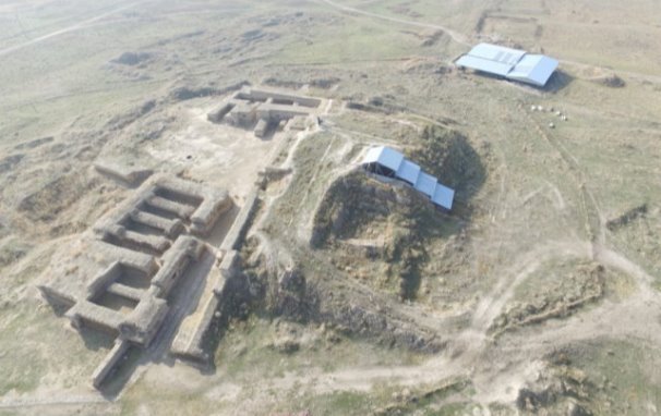
Fig. 1. Citadel of the medieval city of Aktobe, turned into an open-air Museum
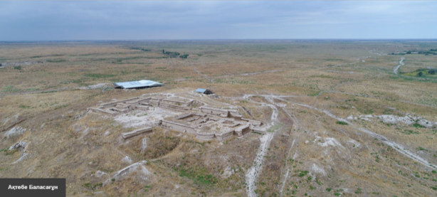
Fig. 2. Medieval city of Aktobe. At the South-West
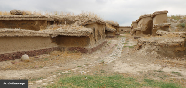
Fig. 3. The entrance to the medieval citadel of the city of Aktobe
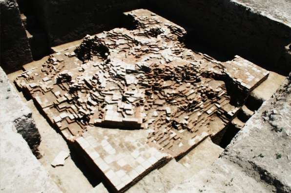
Fig. 4. Tower, found in the medieval city of Aktobe
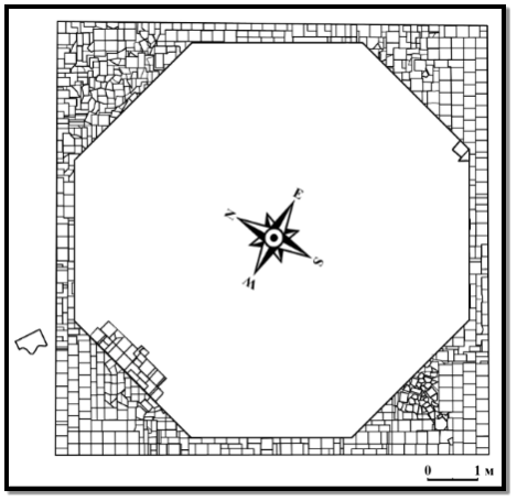
Fig. 5. The scheme of the tower, found in the medieval city of Aktobe.
References:
- Eleuov M. Medieval cities and settlements of Chu-Talas region (VI-XIII centuries): History of Russia. doctor... disk.. — Almaty, 1999. — 360 p.
- E. I. Ageeva, Patsevich, G. I., 1953, South-Kazakhstan archaeological expedition // TIIAE. — 1956. — Vol.1. — P. 33–60.
- Shalekenov W. H. Archaeological studies in Chui, Talas oblasts and the Tau. Report on research activities // Ministry of education and science of the Republic of Kazakhstan Archive of Margulan Institute of archeology. — Almaty, 1994. — 66 p.
- Aldabergenov N. About. The development of the urban tradition in Chui oblast (Aktobe medieval material) // Bulletin of KazNU. Historical series, № 12. — Almaty, 1999. — B. 47–51.
- Akimbek E. Ceramics of the medieval city of Aktobe (VI-XIII centuries). // Thesis for the degree of doctor of philosophy. — Almaty, 2015. — 161 p.
- M. Eleuov, Tuleev D. A. In the Talas region in 2013, Archaeological excavations and excavation // «Actual problems and prospects of development of archaeology and Ethnology of Kazakhstan» in the framework of the 80th anniversary of the birth of academician of the Kazakh national University. Al-Farabi U. H. Proceedings of the international scientific and practical conference dedicated to the 90th anniversary of Shalekenov. May 16, 2014 / Makeup. M. Egamberdiev, A. K. Bacigalova, V. A. Shamieva; good old BK Qalsabaeva. — Almaty: Kazakh University, 2014. — 327 p.
- Margulan A. H. the Third season of archaeological works in Central Kazakhstan (expedition report 1948). // News of the Kazakh SSR. A series of archaeological. Vıp.3. 1951 № 108. — P 3–52.
- Ageeva E. I. Review of findings // Proceedings of the IAEA of the Kazakh SSR. — 1962. vol. 14. — Pp. 386–387.
- P. N. Kozhemyako. Historical cities and settlements of the Chui valley. — Frunze, Typography A. N. Kingsr. — 1959–185 p.
- SADIGOVA T. N. Medieval Taraz. — Alma-ATA, Science. — 1972. — 219 p.
- Baipakov K. M. Medieval cities of Taraz city Museum under the open gallery/ K. M. Baipakov; Author Baranowski/banner/ Banner work. March 8-March 8-P. 2.
- Rysdale. Turkic era of stone sculpture Museum // Egemen Kazakhstan. — November 28, 2003 (N 310).- 2 p.
- Khashimov sh. Open skies: In Taraz there is a Museum of archeology, the city-Museum of history and modernity. Khashimov // Business Kazakhstan. — February 17, 2006. (N 3). — P. 8.
- Shaukharov N. Sugar sites: [2000 — Taraz]. / N. Shaukharov // Banner of labor. — 1996.- April 13, 3, p.
- S. Aliev G. I. Patsevich (1893–1970) and Zhambyl regional Museum: the archaeological excavations and scientific works of the researchers of history Aulieata. / S. Aliyev // History Of Kazakhstan. — 2004. — Oh. No. 5, p 89–91
- M. Eleuov Monuments left unattended. — Turkestan, publisher I. A. Yassawi, 2005. — 119 p.
- Innovative report. Archaeological excavations in the middle of the 19th century in Aktobe. — Alma-ATA, 1980. 130 p.
- Aliev Z., Bevz V. Yu., Ibragimov, I. M. geological structure and relief of the Chuya depression // Chinese landscapes of the Shu depression. — Frunze, Ilim, 1985. — 462 hours.

