


First, true global navigating service can provide only use of companions, as any other system will obviously have local character. Land stations can be placed only in territory of the country or the friendly countries, sea open spaces in this case at all do not give in to full coverage. Secondly, use of the stations which are on a terrestrial surface, does not allow with necessary accuracy to define object height. Besides, use of the companions radiating a super high-frequency signal, allows to make the user equipment rather mobile. Mobility rises also because the greatest possible functional loading is taken out on companions and land stations of management, and the mobile intake should make only definitive processing of in advance prepared information. Each companion which is a part GPS, radiates a radio signal of a certain sort. Any user device GPS, civil or military, first, is the receiver of these radio signals (therefore there was not correct word combination «receiver GPS»). However, signals need to be accepted from companions, it is necessary to make measurement of their parameters, to take the information put in them and to make difficult enough calculations. The received information is necessary for displaying in a kind, clear to the person more often. The device which makes all these operations, name the user terminal (or Reception by the indicator) GPS whereas simply receiver GPS usually is only the module of more difficult device or complex system. However, it is traditional, in a life, mobile terminals GPS name simply receivers. As it often happens, requirements stimulate occurrence of new possibilities, and new possibilities, in turn generate new ideas and requirements. Therefore, for example, with the advent of portable receivers GPS there was an idea of creation of essentially new automobile system of safety. Such system is capable to trace precisely co-ordinates of the car and to transfer them to a control post, using usual cellular communication. There was a possibility essentially to reconstruct a control system of movement of trains, placing on them receivers GPS. The new system is capable to not only trace and optimize precisely movement of trains, but automatically to include a mode of emergency braking at dangerous rapprochement of structures [1].
More togas, now GPS are used even for the decision of such extremely critical problem, as automatic deducing of flying machines on landing path and further to a point of a contact with a runway. Certainly, in this case, especially rigid demands are made to system and special functional additions are applied. For example, precisely positioned land transmitter simulating сигал of the companion (pseudo-list) can be supplementing component. Abroad absence of unreasonable bureaucratic barriers and price availability of household receivers GPS have made the equipment of satellite positioning an obligatory element of equipment of tourists, hunters, anglers — differently, all who is compelled to travel far from the house. Foreign automobile firms build in equipment GPS some models of cars as the regular equipment. While it is only expensive models, but the tendency to a complete set by terminals GPS and models of an average price range is observed. It is possible not to doubt that sooner or later receiver GPS becomes an obligatory component of any car. These facts prove once again that in the near future systems of satellite navigation will influence more and more quality of our everyday life, and the information on their device and possibilities has the big informative value for people, the interested achievements of a modern science. Systems of satellite navigation and their appendix represent one of most dynamically developing branches of world economy. If to 2000 year, the total turnover of its production has made about 1 billion euro to 2005 year it will exceed 8 billion euro. The equipment of satellite navigation has found wide application and as considered as regular for sea and aircrafts, and at all most high-class, space vehicles. It became habitual means in land management, at monitoring, shootings of district and geodetic works. Release of rather inexpensive consumer equipment has caused the beginning of its occurrence in our life, sports, tourism and travel. Amazing distribution has received use of satellite equipment for automobile navigation. By 2000 year, relative density of a total cost of such devices in the European market according to firm Thales1 has made 73 % whereas shares of aircraft and marine sea fleet have not exceeded 5 and 4 % accordingly.
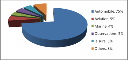
Figure 1: Distribution of European market SRNS
However we are on the threshold of even more powerful changes owing to the issued tendency to integration of mobile phones MS (Mobile Station) and receivers SRNS (Satellite radio navigating systems). The first samples of incorporated equipment GSM+GPS of firm Benison are let out on our market. Under forecast, Thales to 2005 years on united with GPS «tubes» 73 % of the European market of products SRNS, on automobile receivers — 23 % will have, and shares of aviation and sea means will not exceed 1 % everyone (a Fig. 1.1.). Association of satellite navigating and mobile telecommunication technologies is defined by aspiration to provide the user exact knowledge of a place for its reference to information sources and effective work of service of rescue. Thus, satellite receivers have begun intrusion into area of communication, processing and data transmission, information technology and the Internet. At the same time satellite, radio-navigating systems are not at a stop. It is in a development and modernization GPS stage. All these factors define and support steady interest to questions of satellite navigation and its appendices from many readers, which is not satisfied with the available literature. Became a rare book; to the known book «Global satellite radio navigating system GLONASS» at all its advantages it is peculiar quite clear односторонность, such editions as «the Interface control document GLONASS», publications in periodic magazines have the limited circulation and the readers-experts, basically, in the field of radio engineering and navigation.
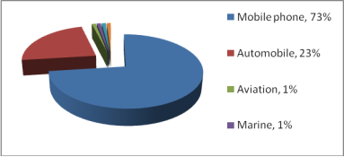
Figure 2: Distribution of European market SRNS, 2005 year.
History of development SRNS: After the invention of radio and working out of designs of the directed aerials, quite obvious attempts to apply to the purposes of navigation the radio beacons working outside of optical visibility have been undertaken. Except sea navigation, radio beacons became widely will be applied (and are applied until now) in aircraft to a lining and correction of a course of flying machines. As a rule, they work in a range of average waves, and for signal reception the combined frame aerial with the narrow diagram me of an orientation is used. There are VHF-range beacons. Distinguish aviation radio beacons of a distant and near drive. Radio beacons allow correcting indications of an onboard magnetic compass and partially to replace or duplicate it. Accuracy of work of an onboard radio compass allows pilots guaranteed to leave on such distance to airdrome at which the further visual orientation in space, for example, on district (small aircraft) or runway fires is possible. Problem in that there are no aerials with the ideal diagram me of an orientation, and the more sharply an aerial orientation, the more difficult its design. Besides, if we want, that the positioning system operated outside of optical visibility, we should use long enough radio waves, capable to bend around horizon. However, it is more long waves, the ideal directed aerial should have the big physical sizes. Therefore, accuracy of action of the directed aerial limited its reasonable constructive sizes. The error of definition of an azimuth on a radio beacon, presented to a kind nobody a corner φ, by the elementary geometrical transformations it is possible conditionally project in a counter corner φ ' with top of a position of a radio beacon. It is obvious that taking into account an error of azimuths, instead of exact coordinates we receive a certain area of a probable site. On distances to the radio beacons estimated in hundreds of kilometers, errors of measurement of an azimuth in degree shares are projected in an error of measurement the sites estimated in hundreds of meters. On extended airlines, the error of positioning of the flying machine reaches several kilometers on size of a lateral deviation from a line. In stationary conditions, it is possible to narrow considerably area of a probable site, assuming as a basis such corner of the aerial, which is an average between two extreme authentic positions. However in practice, in the conditions of stably moving object what can be a small vessel choose correct directions extremely difficult as it is required coping all reception antenna knot. Similar mechanical systems are rather expensive and unreliable. Besides is in a case with two transmitters. If they are located on one line with the reception aerial, there is an absolute impossibility of definition of a site. Presence of the third radio transmitter eliminates an ambiguity problem, but only slightly raises accuracy of a fixing. Hence, for the successful decision of a problem of a fixing it is necessary to measure ranges, i.e. distances between the receiver and transmitters. Knowing only ranges to three transmitters located in one plane with the receiver, it is possible to solve a fixing problem unequivocally. Coordinates of object (point) are coordinates of a point of intersection of imagined circles with radiuses R1, R2 and R3, equal to ranges. The third transmitter is necessary for elimination of the possible ambiguity arising at crossing of two circles (a point about and about '). It is obvious that in a case with measurement of ranges the orientation of action of the reception aerial does not influence accuracy of positioning. However, crucial importance is got by accuracy of synchronization of time scales of transmitters and the receiver and size of the error arising at measurement of time of distribution of a signal. Occurrence in 1960 years of extremely exact atomic clock has allowed lowering essentially errors range finder foot method, to level, sufficient for its wide application in practice [2].
Summary.The described examples show the first results basing on data acquired at the mobile phones. On the one hand, the results presented in chapter 3 show some difficulties when the research problem methods for positioning and matching are applied. On the other hand, no geodetic accuracy has to be achieved. The determined deviations range from few 10 meters up to several 100 meters. The objective is to get an assignment of the mobile phone to the road network. A final solution for the specified application has been identified,
References:
- Jiyun Lee. GPS-based aircraft landing systems with enhanced performance:beyond accuracy March 2005
- J. Eberspächer, H.-J. Vögel, C. Bettstetter and C. Hartmann GSM — Architecture, Protocols and Services Third Edition 2009 John Wiley & Sons, Ltd.
- А. В. Печаткин. Cистемы мобильной связи часть 1 Рыбинск 2008
- Галкин В. А. Цифровая мобильная радиосвязь. Учебное пособие для вузов. — М.: Горячая линия–Телеком, 2007.
